


Posts by AltonParrish:
Proof Of King Solomon’s Mines
October 18th, 2013By Tel Aviv University.
New findings from an archaeological excavation led this winter by Dr. Erez Ben-Yosef of Tel Aviv University’s Jacob M. Alkow Department of Archaeology and Near Eastern Cultures prove that copper mines in Israel thought to have been built by the ancient Egyptians in the 13th century BCE actually originated three centuries later, during the reign of the legendary King Solomon.

Credit: Tel Aviv University
“The mines are definitely from the period of King Solomon,” says Dr. Ben-Yosef. “They may help us understand the local society, which would have been invisible to us otherwise.”
Slaves to history
Now a national park, Timna Valley was an ancient copper production district with thousands of mines and dozens of smelting sites. In February 2013, Dr. Ben-Yosef and a team of researchers and students excavated a previously untouched site in the valley, known as the Slaves’ Hill. The area is a massive smelting camp containing the remains of hundreds of furnaces and layers of copper slag, the waste created during the smelting process.

Nineteenth-century engraving by Gustave Doré
The archaeological record shows the mines in Timna Valley were built and operated by a local society, likely the early Edomites, who are known to have occupied the land and formed a kingdom that rivaled Judah. The unearthed materials and the lack of architectural remains at the Slaves’ Hill support the idea that the locals were a semi-nomadic people who lived in tents.
The findings from the Slaves’ Hill confirm those of a 2009 dig Ben-Yosef helped to conduct at “Site 30,” another of the largest ancient smelting camps in Timna Valley. Then a graduate student of Prof. Thomas E. Levy at the University of California, San Diego, he helped demonstrate that the copper mines in the valley dated from the 11th to 9th centuries BCE — the era of Kings David and Solomon — and were probably Edomite in origin. The findings were reported in the journal The American Schools of Oriental Research in 2012, but the publication did little to shake the notion that the mines were Egyptian, based primarily on the discovery of an Egyptian Temple in the center of the valley in 1969.
Power without stone
The Slaves’ Hill dig also demonstrates that the society in Timna Valley was surprisingly complex. The smelting technology was relatively advanced and the layout of the camp reflects a high level of social organization. Impressive cooperation would have been required for thousands of people to operate the mines in the middle of the desert.

“In Timna Valley, we unearthed a society with undoubtedly significant development, organization, and power,” says Ben-Yosef. “And yet because the people were living in tents, they would have been transparent to us as archaeologists if they had been engaged in an industry other than mining and smelting, which is very visible archaeologically.”
Although the society likely possessed a degree of political and military power, archaeologists would probably never have found evidence of its existence if it were not for the mining operation. Ben-Yosef says this calls into question archaeology’s traditional assumption that advanced societies usually leave behind architectural ruins. He also says that the findings at the Slaves’ Hill undermine criticisms of the Bible’s historicity based on a lack of archaeological evidence. It’s entirely possible that David and Solomon existed and even that they exerted some control over the mines in the Timna Valley at times, he says.
Dr. Ben-Yosef is leading another dig at the Slaves’ Hill in the winter and is looking for volunteers
Unique Skull Throws Human Evolution Theories Into Turmoil
October 18th, 2013By University of Zurich.


Picture: Georgian National Museum
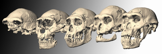

Credit: University of Zurich
Computer reconstruction of the five Dmanisi skulls 

Picture: Fernando Javier Urquijo
Next Yellowstone Caldera Super Eruption Predicted By Scientists
October 14th, 2013By Oregon University.

The pattern emerging from new and previous research completed in the last five years under a National Science Foundation career award, said UO geologist Ilya N. Bindeman, is that another super-eruption from the still-alive Yellowstone volcanic field is less likely for the next few million years than previously thought (see related story, “Not in a million years, says Oregon geologist about Yellowstone eruption“). The last eruption 640,000 years ago created the Yellowstone Caldera and the Lava Creek Tuff in what is now Yellowstone National Park.

Credit: University of Oregon

The Picabo volcanic field of southern Idaho, described in a new paper by a six-member team, was active between 10.4 and 6.6 million years ago and experienced at least three, and maybe as many as six, violent caldera-forming eruptions. The field has been difficult to assess, said lead author Dana Drew, a UO graduate student, because the calderas have been buried by as much as two kilometers of basalt since its eruption cycle died.
The work at Picabo is detailed in a paper online ahead of publication in the journal Earth and Planetary Science Letters.
The team theorized that basalt from the mantle plume, rocks from Earth’s crust and previously erupted volcanoes are melted together to form the rhyolites erupted in the Snake River Plain. Before each eruption, rhyolite magma is stored in dispersed pockets throughout the upper crust, which are later mixed together, according to geochemical evidence. “We think that this batch-assembly process is an important part of caldera-forming eruptions, and generating rhyolites in general,” Drew said.
In reaching their conclusions, Drew and colleagues analyzed radiogenic and stable isotopic data — specifically oxygen and hafnium — in zircons detected in rhyolites found at the margins of the Picabo field and from a deep borehole. That data, in combination with whole rock geochemistry and zircon uranium-lead geochronology helped provide a framework to understand the region’s ancient volcanic past.
Previous research on the related Heise volcanic field east of Picabo yielded similar results. “There is a growing database of the geochemistry of rhyolites in the Yellowstone hotspot track,” Drew said. “Adding Picabo provides a missing link in the database.
Path of the Yellowstone hot spot over the past 16 million years

The approach provided a glimpse into the connection of surface and subsurface processes at a caldera cluster. The interaction of erupted rhyolite with groundwater and surface water causes hydrothermal alteration and the change in oxygen isotopes, thereby providing a fingerprinting tool for the level of hydrothermal alteration, Drew said.
“Through the eruptive sequence, we begin to generate lower delta-O-18 signatures of the magmas and, with that, we also see a more diverse signature,” Drew said. “By the time of the final eruption there is up to five per mil diversity in the signature recorded in the zircons.” The team attributes these signatures to the mixing of diverse magma batches dispersed in the upper crust, which were formed by melting variably hydrothermally altered rocks — thus diverse delta-O-18 — after repeated formation of calderas and regional extension or stretching of the crust.
When the pockets of melt are rapidly assembled, the process could be the trigger for caldera forming eruptions, Bindeman said. “That leads to a homogenized magma, but in a way that preserves these zircons of different signatures from the individual pockets of melt,” he said. This research, he added, highlights the importance of using new micro-analytical isotopic techniques to relate geochemistry at the crystal-scale to processes occurring at the crustal-wide scale in generating and predicting large-volume rhyolitic eruptions.
“This important research by Dr. Bindeman and his team demonstrates the enormous impact an NSF CAREER award can have,” said Kimberly Andrews Espy, vice president for research and innovation and dean of the graduate school at the University of Oregon. “The five-year project is providing new insights into the eruption cycles of the Yellowstone hotspot and helping scientists to better predict future volcanic activity.”
Beneath The Sea of Galilee Enormous Monument Found, Near Mysterious Stonehenge Of The Levant
October 14th, 2013By Alton Parrish.
The shores of the Sea of Galilee, located in the North of Israel, are home to a number of significant archaeological sites. Now researchers from Tel Aviv University have found an ancient structure deep beneath the waves as well.
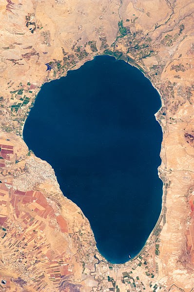
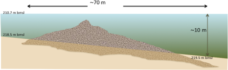
Initial findings indicate that the structure was built on dry land approximately 6,000 years ago, and later submerged under the water. Prof. Marco calls it an impressive feat, noting that the stones, which comprise the structure, were probably brought from more than a mile away and arranged according to a specific construction plan.

Ancient structure revealed by sonar
The team of researchers initially set out to uncover the origins of alluvium pebbles found in this area of the Sea of Galilee, which they believe were deposited by the ancient Yavniel Creek, a precursor to the Jordan River south of the Sea of Galilee. While using sonar technology to survey the bottom of the lake, they observed a massive pile of stones in the midst of the otherwise smooth basin.
Curious about the unusual blip on their sonar, Prof. Marco went diving to learn more. A closer look revealed that the pile was not a random accumulation of stones, but a purposefully-built structure composed of three-foot-long volcanic stones called basalt. Because the closest deposit of the stone is more than a mile away, he believes that they were brought to the site specifically for this structure.
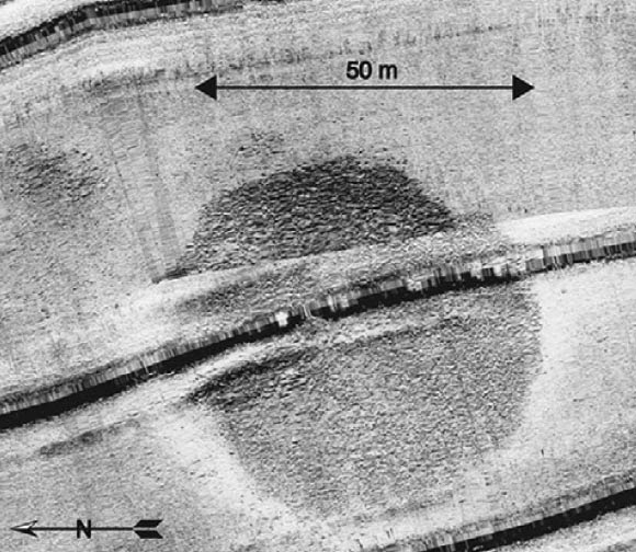
To estimate the age of the structure, researchers turned to the accumulation of sand around its base. Due to a natural build-up of sand throughout the years, the base is now six to ten feet below the bottom of the Sea of Galilee. Taking into account the height of the sand and the rate of accumulation, researchers deduced that the monument is several thousand years old.
Looking deeper
Next, the researchers plan to organize a specialized underwater excavations team to learn more about the origins of the structure, including an investigation of the surface the structure was built on. A hunt for artifacts will help to more accurately date the monument and give clues as to its purpose and builders. And while it is sure to interest archaeologists, Prof. Marco says that the findings could also illuminate the geological history of the region.
The shape and composition of the submerged structure does not resemble any natural feature. We therefore conclude that it is man-made and might be termed a cairn. The boulders had to be transported at least a few hundred metres from the nearest basalt outcrop.
The only period in this region for which megalithic structures can be connected to settlement sites is the Early Bronze Age, between the late 4th and the late 3rd millennia BCE. The monumental site of Khirbet Beteiha, located some 30 km north-east of the submerged stone structure, comprises three concentric stone circles, the largest of which is 56 m in diameter.
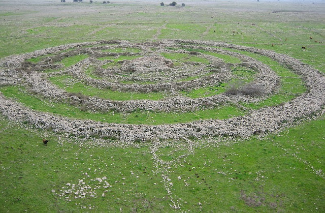
The unique megalithic site of Rogem Hiri, 17 km east of Khirbet Beteiha, includes four stone rings with an inner passage grave and has a diameter of 156 m. Many megalithic structures, including stone circles, menhirs, and dolmens are found along the Jordan Valley.
The purpose of the stone rings is still unknown. Some of the theories of its use include:
Worship – According to this hypothesis, the site was used for special ceremonies during the longest and shortest days of the year. It seems, that in the year 3000 BCE, on the longest day, the first rays of the sun shone through the opening in the north-east gate, which is 20 by 29 meters. However, they did not shine in a perfect angle. It is assumed this is because the builders did not have sufficiently accurate architectural tools. The residents probably used the site to worship Tammuz and Ishtar, the gods of fertility, to thank them for the good harvest during the year. After the erection of the tomb in the center, the rays’ path was blocked.
Burial site – It appears that the place of worship later became a burial site for leaders or other important individuals. Supporting this theory was the tomb in the Dolman. However, no human remains were found, only objects pointing to its function as a tomb. Also, even if it were a tomb, that was not the site’s original function, as the tomb is a 1,000 years newer than the site itself.
Dakhma – Archaeologist Rami Arav suggests the site was used like the Dakhmas of the Zoroastrians, in which dead persons were laid out for birds to remove the flesh from their bones.
Calendar – Some believe the site was used an as ancient calendar. At the times of the two equinoxes, the sun’s rays would pass between two rocks, 2m in height, 5m in width, at the eastern edge of the compound. According to Anthony Aveni and Yonatan Mizrachi the entrance to the center opens on sunrise of the summer solstice. Other notches in the walls indicate the spring and fall equinoxes.
Astronomical observations – Perhaps the site was used for astronomical observations of the constellations, probably for religious calculations. Researchers found the site was built with dimensions and scales common for other period structures, and partly based on the stars’ positions
Eisenhower’s “Military-Industrial Complex” Speech Origins and Significance
October 10th, 2013By Alton Parrish.

Inside the Vaults includes highlights from the National Archives in the Washington, DC, area and from the Presidential libraries and regional archives nationwide. These shorts present behind-the-scenes exclusives and offer surprising stories about the National Archives treasures. See more from Inside the Vaults at http://bit.ly/LzQNae.
A Strange Lonely Planet Found Without A Star, Six Times Larger Than Jupiter
October 10th, 2013By PSO.
An international team of astronomers has discovered an exotic young planet that is not orbiting a star. This free-floating planet, dubbed PSO J318.5-22, is just 80 light-years away from Earth and has a mass only six times that of Jupiter. The planet formed a mere 12 million years ago — a newborn in planet lifetimes.

It was identified from its faint and unique heat signature by the Pan-STARRS 1 (PS1) wide-field survey telescope on Haleakala, Maui. Follow-up observations using other telescopes in Hawaii show that it has properties similar to those of gas-giant planets found orbiting around young stars. And yet PSO J318.5-22 is all by itself, without a host star.
“We have never before seen an object free-floating in space that that looks like this. It has all the characteristics of young planets found around other stars, but it is drifting out there all alone,” explained team leader Dr. Michael Liu of the Institute for Astronomy at the University of Hawaii at Manoa. “I had often wondered if such solitary objects exist, and now we know they do.”
During the past decade, extrasolar planets have been discovered at an incredible pace, with about a thousand found by indirect methods such as wobbling or dimming of their host stars induced by the planet. However, only a handful of planets have been directly imaged, all of which are around young stars (less than 200 million years old). PSO J318.5-22 is one of the lowest-mass free-floating objects known, perhaps the very lowest. But its most unique aspect is its similar mass, color, and energy output to directly imaged planets.
“Planets found by direct imaging are incredibly hard to study, since they are right next to their much brighter host stars. PSO J318.5-22 is not orbiting a star so it will be much easier for us to study. It is going to provide a wonderful view into the inner workings of gas-giant planets like Jupiter shortly after their birth,” said Dr. Niall Deacon of the Max Planck Institute for Astronomy in Germany and a co-author of the study.

“Planets found by direct imaging are incredibly hard to study, since they are right next to their much brighter host stars. PSO J318.5-22 is not orbiting a star so it will be much easier for us to study. It is going to provide a wonderful view into the inner workings of gas-giant planets like Jupiter shortly after their birth,” said Dr. Niall Deacon of the Max Planck Institute for Astronomy in Germany and a co-author of the study.
PSO J318.5-22 was discovered during a search for the failed stars known as brown dwarfs. Due to their relatively cool temperatures, brown dwarfs are very faint and have very red colors. To circumvent these difficulties, Liu and his colleagues have been mining the data from the PS1 telescope. PS1 is scanning the sky every night with a camera sensitive enough to detect the faint heat signatures of brown dwarfs. PSO J318.5-22 stood out as an oddball, redder than even the reddest known brown dwarfs.
“We often describe looking for rare celestial objects as akin to searching for a needle in a haystack. So we decided to search the biggest haystack that exists in astronomy, the dataset from PS1,” said Dr. Eugene Magnier of the Institute for Astronomy at the University of Hawaii at Manoa and a co-author of the study. Dr. Magnier leads the data processing team for PS1, which produces the equivalent of 60,000 iPhone photos every night. The total dataset to date is about 4,000 Terabytes, bigger than the sum of the digital version of all the movies ever made, all books ever published, and all the music albums ever released.
The team followed up the PS1 discovery with multiple telescopes on the summit of Mauna Kea on the island of Hawaii. Infrared spectra taken with the NASA Infrared Telescope Facility and the Gemini North Telescope showed that PSO J318.5-22 was not a brown dwarf, based on signatures in its infrared light that are best explained by it being young and low-mass.
By regularly monitoring the position of PSO J318.5-22 over two years with the Canada-France-Hawaii Telescope, the team directly measured its distance from Earth. Based on this distance, about 80 light-years, and its motion through space, the team concluded that PSO J318.5-22 belongs to a collection of young stars called the Beta Pictoris moving group that formed about 12 million years ago. In fact, the eponymous star of the group, Beta Pictoris, has a young gas-giant planet in orbit around it. PSO J318.5-22 is even lower in mass than the Beta Pictoris planet and probably formed in a different fashion.
The discovery paper of PSO J318.5-22 is being published by Astrophysical Journal Letters and is available athttp://arxiv.org/abs/1310.0457. The other key authors of the paper are Katelyn Allers (Bucknell University), Trent Dupuy (Harvard-Smithsonian Center for Astrophysics), and Michael Kotson and Kimberly Aller (University of Hawaii at Manoa).
Understanding The Dangers Of The Fake Marijuana Called ‘Spice’ Or ‘K2’
October 7th, 2013By Alton Parrish.

Credit: American Chemical Society
Jeffery Moran and colleagues note that synthetic marijuana, often marketed as “natural incense,” “potpourri,” Spice or K2, is a significant public health concern, and 1 in 9 high school seniors admit recent use. The products appear across the United States and Europe, and are the second most popular drug after real marijuana for many American teens and young adults. The substances produce a “high,” but also can cause a wide range of dangerous side effects including seizures, hallucinations, severe kidney damage, psychotic behavior and heart attacks. Scientists are quickly playing catch-up to understand how these fake pot products work in order to identify them in users’ urine and to treat the devastating health effects, which, in some cases, plague users for months after they initially take it.
To gain insight into the effects of designer marijuana products, Moran’s team developed a new method and used it to study how the body processes two popular forms in Spice and K2, known as JWH-018 and AM2201. Urine samples from 15 people who tested positive for use showed significant differences in how the individuals’ bodies processed the drugs. This finding could help explain why some people experience more severe effects from the drugs than others.
Research Suggests The Vikings May Have Been More Social Than Savage
October 7th, 2013By Coventry University.

It is generally believed that the texts were written in the 13th and 14th centuries by authors of unknown or uncertain identities but they may have oral prehistory. The texts focus on family histories and genealogies and reflect struggles and conflicts amongst the early settlers of Iceland and their descendants. The sagas describe many events in clear and plausible detail and are considered to be amongstthe gems of world literature and cultural inheritance.
They applied methods from statistical physics to social networks – in which nodes (connection points) represent individuals and links represent interactions between them – to hone in on the relationships between the characters and societies depicted therein.
The academics used the Sagas of Icelanders – a unique corpus of medieval literature from the period around the settlement of Iceland a thousand years ago – as the basis for their investigation.
Although the historicity of these tales is often questioned, some believe they may contain fictionalised distortions of real societies, and Mac Carron’s and Kenna’s research bolsters this hypothesis.
They mapped out the interactions between over 1,500 characters that appear in 18 sagas including five particularly famous epic tales. Their analyses show, for example, that although an ‘outlaw tale’ has similar properties to other European heroic epics, and the ‘family sagas’ of Icelandic literature are quite distinct, the overall network of saga society is consistent with real social networks.
Moreover, although it is acknowledged that J. R. R. Tolkien was strongly influenced by Nordic literature, the Viking sagas have a different network structure to the Lord of the Rings and other works of fiction.
Professor Ralph Kenna from Coventry University’s Applied Mathematics Research Centre said:
This quantitative investigation is very different to traditional approaches to comparative studies of ancient texts, which focus on qualitative aspects. Rather than individuals and events, the new approach looks at interactions and reveals new insights – that the Icelandic sagas have similar properties to those of real-world social networks.
On a wider level, the new approach shows that even after two centuries of scholarly examination, these sagas offer new knowledge if new techniques are applied and new questions asked.
This research demonstrates the importance of what interdisciplinary research between science and humanities can achieve.
The paper, Network analysis of the Íslendingasögur – the Sagas of Icelanders (European Physical Journal B 86 (2013) 407), is available to view online.
Increasing Accessibility Of 3-D Printing Raises Concerns About Plastic Guns
October 4th, 2013By Alton Parrish.

Cuba’s Socialist Renewal: Revolution or Reform
October 3rd, 2013By Marce Cameron.

An important quality, profoundly revolutionary, animated the thinking of Marti: a cultured man of refined sensitivity and an extraordinary scientific understanding, Marti rejected the vulgar materialism, ultimately idealist, of positivism to which many of his peers adhered. There was in Marti something of a “crazy”, indomitable man who rejected almost instinctively the passive compliance with social “deeds”: if the phrase turned into graffiti by an anonymous hand in a Paris street in the 68th year of the following century had an antecedent — the one that asked us if we were realists, and if we would do the impossible — it was perhaps the political realism of the 19th century Marti.
Turning Algae Into Fuel
October 2nd, 2013By Alton Parrish.
Blue-green in colour, slimy and present in seas and fresh water worldwide – the presence of microalgae is not generally met with great excitement. But this may be about to change. A team of European scientists is on a mission to prove that microalgae can be used to produce bioethanol as a biofuel for less than EUR 0.40 a litre.

The EU-funded project DEMA (‘Direct Ethanol from MicroAlgae’) is focusing on cyanobacteria – a microalgae found in almost every terrestrial and aquatic habitat, including in oceans, lakes and damp soil, and on rocks. They obtain their energy via photosynthesis.
The research team is seeking to improve biofuel production at two levels. First, the team will introduce the capacity to produce ethanol through metabolic engineering – by altering the chemical reactions that occur within its cells so that they can produce bioethanol effectively.
The bioethanol will then be secreted by the algae and filtered from the medium through a membrane.
The DEMA team will develop and demonstrate the technology, and is confident that the process, once fine-tuned, will be superior to any other put forward so far in scientific literature.
Biofuels have the potential to significantly reduce transport’s output of carbon and reduce its impact on climate change. Using microalgae to produce biofuels has many advantages over other forms of biomass: it occurs naturally and grows quickly, and as it does not grow on land, it does not compete with food crops.
The project brings together nine partners from both academia and industry from six EU countries. It is coordinated by the University of Limerick in Ireland and has received almost EUR 5 million from the EU under the energy strand of the Seventh Framework Programme (FP7). The project started work in December 2012 and completes its work in May 2017.
Ice Age Coming Again: History Of Climate Must Be Rewritten Say Researchers
October 1st, 2013By Alton Parrish.

AWI geologist Dr. Frank Niessen and colleagues had already discovered the first signs of conspicuous scour marks and sediment deposits on the ocean floor north of Wrangle Island (Russia) on a Polarstern expedition in 2008. However, they were unable to gather extensive proof until last year, during an Arctic expedition on the South Korean research vessel Araon.
The result of this research is a topographic map of the Arlis Plateau, a seamount on which deep, parallel-running furrows can be discerned on the upper plateau and the sides – and over an area of 2500 square kilometres and to an ocean depth of 1200 metres. “We knew of such scour marks from places like the Antarctic and Greenland.
These new findings overturn the traditional textbook view of the history of Arctic glaciations. “Previously, many scientists were convinced that mega-glaciations always took place on the continents – a fact that has also been proven for Greenland, North America, and Scandinavia. However, it was assumed that the continental shelf region of North-eastern Siberia became exposed in these ice ages and turned into a vast polar desert in which there was not enough snow to enable a thick ice shield to form over the years. Our work now shows that the opposite was true. With the exception of the last ice age 21,000 years ago, ice sheets formed repeatedly in the shallow areas of the Arctic Ocean. These sheets were at least 1200 metres thick and presumably covered an area as large as Scandinavia,” says Frank Niessen.
The AWI scientists still cannot say for certain, however, under what climate conditions these ice sheets formed and when exactly they left their marks on the bottom of the Arctic Ocean. “We theorize that the East Siberian ice sheets arose during various ice ages when the average global temperature was around five to eight degrees Celsius cooler than what it is today. But evidently this relatively minor temperature difference was often sufficient to allow initially thin ocean ice to grow into an immense ice cap. An example that shows just how sensitively the Arctic reacts to changes in the global climate system,” says the geologist.

Credit: Alfred Wegener Institute
Frank Niessen and his colleagues are anticipating a great number of surprising discoveries in the Arctic Ocean in the future. “As the Arctic Ocean sea-ice cover continues to shrink, more formerly unexplored ocean area becomes accessible. Today less than ten percent of the Arctic Ocean floor has been surveyed as thoroughly as the Arlis Plateau,” says the AWI geologist. And this study would not have succeeded were it not for the outstanding cooperation of the AWI scientists with researchers of the South Korean Polar Research Institute KOPRI.
Ice ages: About 2.7 million years ago the global climate cooled considerably. We have had a permanent ice cap on Greenland ever since. Then came around 55 changes between ice ages and warm periods until today. About 800,000 years ago the magnitude and duration of the glaciations in the Northern Hemisphere increased considerably. Since then the world climate has regularly alternated between two extremes: each cycle of an ice age followed by a warm period now lasts 100,000 years.
High Risk Situations Interpreted With Surveillance Software
September 30th, 2013By Jaime Ortega.
The prototype of this software is already installed in the research center located in the Mechatronics Laboratory of Queretaro, in central Mexico
The prototype consists of four cameras placed in the laboratory; they can detect situations that a traditional surveillance system does not, for example, how people behave when they enter the building for the first time. If the way they walk is different, the technology developed in CIDESI records it.
Hugo Jiménez Hernández, head of research at CIDESI said the interesting thing is that the system analyzes the behavior of moving objects, and then decides when an unusual event is happening and notifies it.
“In CIDESI’s design, all surveillance cameras work as a data gathering point and decide whether something is relevant or not; when one of the cameras detects something unusual it sends a signal, focuses and analyzes the event. When uncommon things happen the response time is very fast and the number of events it detects increases”
With this technology, the unusual event is sent to a central server to analyze the flow of moving objects, so that when it locates the event, it reports and saves the corresponding video fragment along with the time and the code of the camera that registered it.
This technology can also elaborate behavioral statistics, for example if the system were installed in a high traffic crossroad, where it would be more probable for an accident to occur in rush hour, the software would report so in order to prevent it.
This information is registered on a data base that obtains and analyzes the statistics, particularly the ones recorded on the day of the unusual event in order to inform about potential risk situations. In the case of an event that requires extra attention, the system can respond within seconds, so an alarm can be activated.
“This technology only records unusual situations and doesn’t require large resources as the traditional surveillance systems, making it a low cost technology and an efficient information system. To detect and anomaly no sequence search on every hour of the surveillance video is needed.”
For the time being, this technology has potential clients in the private and public areas. For example, the Ministry of Transport in Querétaro could employ it as a tool to monitor roads and avenues. And private companies could use a surveillance system oriented toward malls or busy locations.
This technological development was accomplished with the help of the Center of Research in Applied and Advanced Technology (CICATA), the National Polytechnic Institute (IPN) and the Autonomous University of Queretaro (UAQ). Currently, is in process of being patented and obtain copyrights. (Agencia ID)
NASA, Homeland Security Test Disaster Recovery Tool
September 28th, 2013
By NASA.
The prototype technology, called Finding Individuals for Disaster and Emergency Response (FINDER) can locate individuals buried as deep as 30 feet (about 9 meters) in crushed materials, hidden behind 20 feet (about 6 meters) of solid concrete, and from a distance of 100 feet (about 30 meters) in open spaces.

Image Credit: DHS/John Price
The technology was demonstrated to the media today at the DHS’s Virginia Task Force 1 Training Facility in Lorton, Va. Media participated in demonstrations that featured the device locating volunteers hiding under heaps of debris. FINDER also will be tested further by the Federal Emergency Management Agency this year and next.
“The ultimate goal of FINDER is to help emergency responders efficiently rescue victims of disasters,” said John Price, program manager for the First Responders Group in Homeland Security’s Science and Technology Directorate in Washington. “The technology has the potential to quickly identify the presence of living victims, allowing rescue workers to more precisely deploy their limited resources.”
The technology works by beaming microwave radar signals into the piles of debris and analyzing the patterns of signals that bounce back. NASA’s Deep Space Network regularly uses similar radar technology to locate spacecraft. A light wave is sent to a spacecraft, and the time it takes for the signal to get back reveals how far away the spacecraft is. This technique is used for science research, too. For example, the Deep Space Network monitors the location of the Cassini mission’s orbit around Saturn to learn about the ringed planet’s internal structure.
“Detecting small motions from the victim’s heartbeat and breathing from a distance uses the same kind of signal processing as detecting the small changes in motion of spacecraft like Cassini as it orbits Saturn,” said James Lux, task manager for FINDER at JPL.
In disaster scenarios, the use of radar signals can be particularly complex. Earthquakes and tornadoes produce twisted and shattered wreckage, such that any radar signals bouncing back from these piles are tangled and hard to decipher. JPL’s expertise in data processing helped with this challenge. Advanced algorithms isolate the tiny signals from a person’s moving chest by filtering out other signals, such as those from moving trees and animals.
Similar technology has potential applications in NASA’s future human missions to space habitats. The astronauts’ vital signs could be monitored without the need for wires.
The Deep Space Network, managed by JPL, is an international network of antennas that supports interplanetary spacecraft missions and radio and radar astronomy observations for the exploration of the solar system and the universe. The network also supports selected Earth-orbiting missions.
For more information about NASA programs, visit: http://www.nasa.gov .
Astronomers Find ‘Missing Link’ Pulsar
September 26th, 2013By CSIRO.
The cosmic drama is being played out 18,000 light-years away, in a small cluster of stars (M28) in the constellation of Sagittarius.
The pulsar (called PSR J1824-2452I) has a tiny companion star, with about a fifth the mass of the Sun. Although small, the companion is fierce, pounding the pulsar with streams of matter.
Normally the pulsar shields itself from this onslaught, its magnetic field deflecting the matter stream into space.

But sometimes the stream swells to a flood, overwhelming the pulsar’s protective ‘force field’. When the stream hits the pulsar’s surface its energy is released as blasts of X-rays.
Eventually the torrent slackens. Once again the pulsar’s magnetic field re-asserts itself and fends off the companion’s attacks.
“We’ve been fortunate enough to see all stages of this process, with a range of ground and space telescopes. We’ve been looking for such evidence for more than a decade,” said Dr Alessandro Papitto, the Nature paper’s lead author. Dr Papitto is an astronomer of the Institute of Space Studies of Barcelona.
The pulsar and its companion form what is called a ‘low-mass X-ray binary’ system. In such a system, the matter transferred from the companion lights up the pulsar in X-rays and makes it spin faster and faster, until it becomes a ‘millisecond pulsar’ that spins at hundreds of times a second and emits radio waves. The process takes about a billion years, astronomers think.
In its current state the pulsar is exhibiting behaviour typical of both kinds of systems: millisecond X-ray pulses when the companion is flooding the pulsar with matter, and radio pulses when it is not.
“It’s like a teenager who switches between acting like a child and acting like an adult,” said Mr John Sarkissian, who observed the system with CSIRO’s Parkes radio telescope.
“Interestingly, the pulsar swings back and forth between its two states in just a matter of weeks.”
The pulsar was initially detected as an X-ray source with the INTEGRAL satellite. X-ray pulsations were seen with another satellite, ESA’s XMM-Newton; further observations were made with NASA’s Swift. NASA’s Chandra X-ray telescope got a precise position for the object.
Then, crucially, the object was checked against the pulsar catalogue generated by CSIRO’s Australia Telescope National Facility, and other pulsar observations. This established that it had already been identified as a radio pulsar.
The source was detected in the radio with CSIRO’s Australia Telescope Compact Array, and then re-observed with CSIRO’s Parkes radio telescope, NRAO’s Robert C. Byrd Green Bank Telescope in the USA, and the Westerbork Synthesis Radio Telescope in The Netherlands. Pulses were detected in a number of these later observations, showing that the pulsar had ‘revived’ as a normal radio pulsar only a couple of weeks after the last detection of the X-rays.
The astronomers involved in these investigations work at institutions in Australia, Canada, Germany Italy, The Netherlands, Spain, Switzerland, and the USA
NASA Sees Deadly Typhoon Usagi Hit Southern China
September 24th, 2013By Nasa.

Image Credit: NASA/SSAI, Hal Pierce
Satellite data on Sept. 22 showed that Usagi’s eye was about 10 nautical miles wide and beginning to cross the China coast. NASA’s TRMM satellite passed overhead on Sept. 22 at 0923 UTC/5:23 a.m. EDT as the storm was making landfall, and TRMM saw very heavy rainfall in the southern quadrant of the storm. There were areas just south of Usagi’s eye where rain was falling at a rate of over 169mm/~6.7 inches per hour along China’s coast. TRMM radar sliced through Usagi and found that heights of some thunderstorms were reaching only about 12 km /7.4 miles but were returning values of over 54dBZ to TRMM’s Precipitation Radar (PR) instrument.

Image Credit: SSAI/NASA, Hal Pierce
Xinhuanet reported that about 8,490 houses collapsed and there was damage to about 50,800 hectares of cropland. As Usagi’s remnants move over land the rugged terrain north of Hong Kong toward Guangzhou will cause it to dissipate within two days.
Oldest Hoard Of Jewelry Yet Found In Europe, 8000 Years Old From Serbia
September 22nd, 2013By Alton Parrish.
“Important finds like this should be prominently displayed in the Serbian National Museum,” says Krauss of the hoard. “But the National Museum in Belgrade has been closed since the civil war.” So Krauss is working with his Serbian colleagues on an exhibition at the University of Tübingen Museum in Hohentübingen Castle. The modern world will first get to see the Belica hoard there in the winter semester of 2013/14. The hoard, and the results of the current investigation, are to be published in German and Serbian.
Stronger Sexual Impulses May Explain Why Men Cheat More Than Women, Study Reveals
September 22nd, 2013By University of Austin Texas.
Previous research has shown that men are more likely than women to pursue romantic partners that are “off limits.” However, until now, the explanation for this sex difference was largely unexplored.
One possible explanation for this effect is that men experience stronger sexual impulses than women do. A second possibility is that women have better self-control than men. The current study’s results support the former explanation and provide new insight into humans’ evolutionary origins.
“Overall, these studies suggest that men are more likely to give in to sexual temptations because they tend to have stronger sexual impulse strength than women do,” says Natasha Tidwell, a doctoral student in the Department of Psychology at Texas A&M University, who authored the study. Paul Eastwick, assistant professor in the Department of Human Development and Family Sciences at The University of Texas at Austin, co-authored the study.
“But when people exercise self-control in a given situation, this sex difference in behavior is greatly reduced. It makes sense that self-control, which has relatively recent evolutionary origins compared to sexual impulses, would work similarly — and as effectively — for both men and women,” Tidwell said.
Recently published in Personality and Social Psychology Bulletin, the study was composed of two separate experiments: the first, to determine how the sexes reacted to real-life sexual temptations in their past and, the second, to pick apart sexual impulses and self-control using a rapid-fire reaction time task.
In order to test their first hypothesis, researchers recruited 218 (70 male, 148 female) study participants from the United States.
Participants were first asked to recall and describe an attraction to an unavailable or incompatible member of the opposite sex. They then answered survey questions designed to measure strength of sexual impulse, attempts to intentionally control the sexual impulse, and resultant behaviors.
“When men reflected on their past sexual behavior, they reported experiencing relatively stronger impulses and acting on those impulses more than women did,” says Tidwell.
However, men and women did not differ in the extent to which they exerted self-control.
“When men and women said they actually did exert self-control in sexual situations, impulse strength didn’t predict how much either sex would actually engage in ‘off-limits’ sex,” added Tidwell.
“Men have plenty of self-control — just as much as women,” says Eastwick. “However, if men fail to use self-control, their sexual impulses can be quite strong. This is often the situation when cheating occurs.”
In order to measure the strength of sexual impulse relative to the strength of impulse control, the researchers recruited 600 undergraduate students (326 men, 274 women) to participate in a “Partner Selection Game.”
Participants were very briefly shown images of opposite-sex individuals; the images were tagged either “good for you” or “bad for you.” Participants were asked to accept or reject potential partners based on the computer-generated “good for you” or “bad for you” prompt. While they were shown photographs of both desirable and undesirable individuals, participants were instructed to make acceptance and rejection choices based on the computer-generated tags. In some trials, participants were asked to accept desirable and reject undesirable individuals; in other trials, participants were asked to go against their inclinations by rejecting desirable individuals and accepting undesirable individuals.
Men experienced a much stronger impulse to “accept” the desirable rather than the undesirable partners, and this impulse partially explained why men performed worse on the task than women did. However, this same procedure estimates people’s ability to exert control over their responses, and men did not demonstrate a poorer ability to control their responses relative to women.
One Foot From The Grave! You Won’t Believe This!
September 19th, 2013By Alton Parrish.


Credit: University of Leicester
The University of Leicester led the search for the Anointed King who died at the battle of Bosworth in association with Leicester City Council and the Richard III Society. The University team dug three trenches under a Leicester car park before their discovery was made.
Now site director Mathew Morris has disclosed that the remains were found just inches below Victorian foundations. Had the 19th century builders dug a little further-no remains would have been found.
Mathew said: “It was incredibly lucky. If the Victorians had dug down 30cm more they would have built on top of the remains and destroyed them.”
City Mayor Sir Peter Soulsby added: “It is extremely lucky that the remains were found at all.
“His head was discovered inches from the foundations of a Victorian building. They obviously did not discover anything and probably would not have been aware of the importance of the site.
“If their plans had been just a little different, they could have destroyed a most significant historic find.”
A team from the University of Leicester, including archaeologists and geneticists, is now engaged in a scientific investigation to determine whether the remains are indeed of King Richard III.
Using DNA extracted from Michael Ibsen, believed to be a descendant of King Richard III’s sister, the team will seek to determine if there is a match.
The entire dig was filmed by Darlow Smithson Productions for a Channel 4 Documentary.
300 Year Old Riddle Answered: What Direction Does The Solid Center Of Earth Spin
September 19th, 2013By University of Leeds.

Credit: University of Leeds
Earth’s inner core, made up of solid iron, ‘superrotates’ in an eastward direction — meaning it spins faster than the rest of the planet — while the outer core, comprising mainly molten iron, spins westwards at a slower pace.
Although Edmund Halley — who also discovered the famous comet — showed the westward-drifting motion of Earth’s geomagnetic field in 1692, it is the first time that scientists have been able to link the way the inner core spins to the behavior of the outer core. The planet behaves in this way because it is responding to Earth’s geomagnetic field.
The findings, published today in Proceedings of the National Academy of Sciences, help scientists to interpret the dynamics of the core of Earth, the source of our planet’s magnetic field.
In the last few decades, seismometers measuring earthquakes travelling through Earth’s core have identified an eastwards, or superrotation of the solid inner core, relative to Earth’s surface.
“The link is simply explained in terms of equal and opposite action,” explains Dr Philip Livermore, of the School of Earth and Environment at the University of Leeds. “The magnetic field pushes eastwards on the inner core, causing it to spin faster than Earth, but it also pushes in the opposite direction in the liquid outer core, which creates a westward motion.”
The solid iron inner core is about the size of the Moon. It is surrounded by the liquid outer core, an iron alloy, whose convection-driven movement generates the geomagnetic field.
The fact that Earth’s internal magnetic field changes slowly, over a timescale of decades, means that the electromagnetic force responsible for pushing the inner and outer cores will itself change over time. This may explain fluctuations in the predominantly eastwards rotation of the inner core, a phenomenon reported for the last 50 years by Tkalčić et al. in a recent study published in Nature Geoscience.
Other previous research based on archeological artefacts and rocks, with ages of hundreds to thousands of years, suggests that the drift direction has not always been westwards: some periods of eastwards motion may have occurred in the last 3,000 years. Viewed within the conclusions of the new model, this suggests that the inner core may have undergone a westwards rotation in such periods.
The authors used a model of Earth’s core which was run on the giant super-computer Monte Rosa, part of the Swiss National Supercomputing Centre in Lugano, Switzerland. Using a new method, they were able to simulate Earth’s core with an accuracy about 100 times better than other models.