


Posts by AltonParrish:
ET Iron Man: Priceless Thousand Year Old Statue Is First Carving Of A Human In A Meteorite
September 15th, 2013By Alton Parrish.

Credit: Stuttgart University, Elmar Buchner
It sounds like an artifact from an Indiana Jones film; a 1,000 year-old ancient Buddhist statue which was first recovered by a Nazi expedition in 1938 has been analysed by scientists and has been found to be carved from a meteorite. The findings, published in Meteoritics and Planetary Science, reveal the priceless statue to be a rare ataxite class of meteorite.
A thousand year-old ancient Buddhist statue known as the Iron Man

The statue was discovered in 1938 by an expedition of German scientists led by renowned zoologist Ernst Schäfer. The expedition was supported by Nazi SS Chief Heinrich Himmler and the entire expeditionary team were believed to have been SS members.
Schäfer would later claim that he accepted SS support to advance his scientific research into the wildlife and anthropology of Tibet. However, historians believe Himmler’s support may have been based on his belief that the origins of the Aryan race could be found in Tibet.
It is unknown how the statue was discovered, but it is believed that the large swastika carved into the centre of the figure may have encouraged the team to take it back to Germany. Once it arrived in Munich it became part of a private collection and only became available for study following an auction in 2007.
The first team to study the origins of the statue was led by Dr Elmar Buchner from Stuttgart University. The team was able to classify it as an ataxite, a rare class of iron meteorite with high contents of nickel.
“The statue was chiseled from a fragment of the Chinga meteorite which crashed into the border areas between Mongolia and Siberia about 15,000 years ago,” said Dr Buchner. “While the first debris was officially discovered in 1913 by gold prospectors, we believe that this individual meteorite fragment was collected many centuries before.”
Meteorites inspired worship from many ancient cultures ranging from the Inuit’s of Greenland to the aborigines of Australia. Even today one of the most famous worship sites in the world, Mecca in Saudi Arabia, is based upon the Black Stone, believed to be a stony meteorite. Dr Buchner’s team believe the Iron Man originated from the Bon culture of the 11th Century.
“The Iron Man statue is the only known illustration of a human figure to be carved into a meteorite, which means we have nothing to compare it to when assessing value,” concluded Dr Buchner. “Its origins alone may value it at $20,000; however, if our estimation of its age is correct and it is nearly a thousand years old it could be invaluable.”
The fall of meteorites has been interpreted as divine messages by multitudinous cultures since prehistoric times, and meteorites are still adored as heavenly bodies. Stony meteorites were used to carve birds and other works of art; jewelry and knifes were produced of meteoritic iron for instance by the Inuit society.
Approximately 10.6 kg of the Buddhist sculpture (the “iron man”) is made of an iron meteorite, which represents a particularity in religious art and meteorite science. The specific contents of the crucial main (Fe, Ni, Co) and trace (Cr, Ga, Ge) elements indicate an ataxitic iron meteorite with high Ni contents (approximately 16 wt%) and Co (approximately 0.6 wt%) that was used to produce the artifact.
In addition, the platinum group elements (PGEs), as well as the internal PGE ratios, exhibit a meteoritic signature. The geochemical data of the meteorite generally match the element values known from fragments of the Chinga ataxite (ungrouped iron) meteorite strewn field discovered in 1913. The provenance of the meteorite as well as of the piece of art strongly points to the border region of eastern Siberia and Mongolia, accordingly. The sculpture possibly portrays the Buddhist god Vaiśravana and might originate in the Bon culture of the eleventh century. However, the ethnological and art historical details of the “iron man” sculpture, as well as the timing of the sculpturing, currently remain speculative.
Catastrophic Collapse Of Ice Lake Created Aram Chaos On Mars
September 15th, 2013
By Europlanet.
Credit: Europlanet
Chaotic terrains are enigmatic features, stretching up to hundreds of kilometers across, that are distinctive to Mars. The mechanism by which they formed has been poorly understood by scientists.
“About 3.5 billion years ago, the pristine Aram impact crater was partly filled with water ice that was buried under a two-kilometre thick layer of sediment. This layer isolated the ice from surface temperatures, but it gradually melted over a period of millions of years due to the heat released by the planet. The sediment overlying fluid water became unstable and collapsed,” said Roda.
Prospective view of Aram Valley inlet The Aram Valley is a deep (2 km) V-shaped valley which connects Aram Chaos to the Ares Vallis.
The resulting massive expulsion of a hundred thousand cubic kilometres of liquid water was four times the volume of Lake Baikal, the largest freshwater lake on Earth. The water carved a valley of 10 kilometres wide and 2 kilometres deep in about one month and a chaotic pattern of blocks was left in the Aram crater.
“An exciting consequence is that rock-ice units are possibly still present in the subsurface. These never achieved the melting conditions, or melted only a lower thin layer, insufficient to result in a full collapse event. Buried ice lakes testify of Mars rapidly turning into a cold, frozen planet, but with lakes buried in the subsurface. These lakes could provide a potentially favourable site for life, shielded from hazardous UV radiation at the surface,” said Roda.
The study was carried out by Roda and colleagues Tanja E. Zegers, Maarten G. Kleinhans and Rob Govers from Utrecht University and Jelmer H.P. Oosthoek of Jacobs University Bremen.
Lockheed Martin Completes First LRASM Air-Launch Flight Test
September 14th, 2013By Lockheed Martin.

In the test over the Sea Range at Point Mugu, Calif., a U.S. Air Force B-1B from the 337th Test and Evaluation Squadron at Dyess Air Force Base, Texas, released the LRASM. The missile navigated through all planned waypoints, transitioned to autonomous guidance and flew toward the maritime target using inputs from the onboard multimodal sensor. The missile then descended to low altitude for final approach to the target area, positively identified and impacted the target.
“This is a monumental accomplishment for the LRASM program and paves the way for subsequent missile launches,” said Mike Fleming, LRASM air launch program manager at Lockheed Martin Missiles and Fire Control. “The multi-service and industry team was well-coordinated and operated seamlessly in the execution of this very important test.”
LRASM is an autonomous, precision-guided anti-ship standoff missile leveraging the successful Joint Air-to-Surface Standoff Missile Extended Range (JASSM-ER)heritage, and is designed to meet the needs of U.S. Navy and Air Force warfighters in a robust anti-access/area-denial threat environment. JASSM-ER, which recently completed its operational test program, provides a significant number of parts and assembly-process synergies with LRASM, which results in cost savings for the U.S. Navy and Air Force (air- and surface-launched) Offensive Anti-Surface Warfare programs.
After a competition in 2009, Lockheed Martin’s LRASM was selected to demonstrate air- and surface-launched capability to defeat emerging sea-based threats at significant standoff ranges.
Armed with a proven 1,000-pound penetrator and blast-fragmentation warhead, LRASM employs a multi-mode sensor, weapon data link and an enhanced digital anti-jam global positioning system to detect and destroy specific targets within a group of ships.
Lockheed Martin Missiles and Fire Control is a 2012 recipient of the U.S. Department of Commerce’s Malcolm Baldrige National Quality Award for performance excellence. The Malcolm Baldrige Award represents the highest honor that can be awarded to American companies for achievement in leadership, strategic planning, customer relations, measurement, analysis, workforce excellence, operations and business results.
Universe May Be Shaped Like A Saddle, Fabric Of Space And Time Dramatically Different Than Previously Thought
September 14th, 2013By Alton Parrish.
Researchers investigating a major anomaly in the afterglow of the Big Bang suggest the fabric of space and time may actually be curved like a saddle, possibly upending the currently leading notion that light and anything else traveling through spacetime zips through a “flat” universe in straight lines. In a saddle-shaped universe, however, any object that seems like it is traveling parallel to another item will actually veer away from it after vast distances.

Image credit: NASA
However, there may be other explanations for this anomaly, scientists cautioned. Our universe may have collided with another universe shortly after the Big Bang, or the anomaly might just be a statistical fluke.
Researchers began noticing the anomaly in question nearly a decade ago when they analyzed the cosmic microwave background, heat released in the aftermath of the Big Bang. Scientists can study the fluctuations in hot and cold spots in the cosmic microwave background to learn more about the structure and evolution of the universe.
Data from NASA’s Wilkinson Microwave Anisotropy Probe (WMAP), launched in 2001, unexpectedly suggested that the universe may be lopsided — hot and cold spots on one side of the cosmos appear hotter and colder than on the other. The evidence for this anomaly has increased over time, and data from the Planck satellitelaunched by the European Space Agency in 2009 supports the existence of the same anomaly.
“The observed anomalies in the cosmic microwave background are intriguing — they may just be a statistical fluke, but they might be an indication of new physical processes at play in the early universe,” said researcher Andrew Liddle, a cosmologist at the University of Edinburgh in Scotland.
This lopsidedness contradicts the prevailing view in cosmology that moments after the Big Bang, the universe grew titanically in size. This growth spurt, called inflation, would have evened out the cosmos and made it look mostly similar in every direction.
Now cosmologists suggest these anomalies occur because the universe is not flat. Instead, these researchers propose the universe may be ever so slightly “open,” curved in such a way that parallel lines, which never converge or diverge when traveling on a flat surface, will eventually diverge from one another, like on a saddle.
“The light rays in a curved universe appear to follow curved paths,” Liddle said. “They are following lines that are the shortest distance in curved space, just as airplanes follow great circles when flying around the Earth.”
The idea starts with the observable universe forming like a bubble inside a larger “meta-universe.” The act of birth may have triggered fluctuations in the wall of the bubble that would imprint themselves as very large-scale disturbances. One consequence would be this asymmetry in the cosmic microwave background that WMAP and Planck see; another is a universe that looks flat but is actually curved beyond the observable horizon of the universe.
“The amount of inflation that takes place inside the bubble determines how flat the universe is,” Liddle said. “We want there to be enough that it is almost, but not quite, flat.”
This concept “is an extremely intriguing one, particularly as it suggests that there may be other interesting new physics just around the corner,” said theoretical physicist Marc Kamionkowski at Johns Hopkins University in Baltimore, who did not take part in this research. “While still quite speculative, this open universe scenario does seem to provide a more natural way to explain why the distance scale of the asymmetry is so close to the horizon scale today than other scenarios I’ve seen.”
Matthew Kleban, a theoretical physicist at New York University, who also did not participate in this study, said that improving the understanding of the curvature of the universe is very important. “With that said, this certainly doesn’t constitute direct evidence, but it’s tantalizing,” said Kleban.
This concept faces competition from a number of other explanations scientists have bandied about to explain this anomaly. For instance, another universe may have collided with ours, suggest Kleban and his colleagues.
However, all these explanations for this seeming anomaly in the cosmic microwave background that demand a rewrite of the laws of physics may ultimately be moot.
“The majority of cosmologists probably believe that the observed anomalies are a statistical fluke rather than a real property of the universe, which is an entirely reasonable point of view,” Liddle said.
In 2014, the Planck team could reveal whether the anomaly is indeed a fluke when it releases more data on the cosmic microwave background. The idea of a saddle-shaped universe may be supported if the distribution of temperatures in the sky does not follow a bell curve.
Liddle and his colleague Marina Cortês detail their findings in the Sept. 13 issue of the journal Physical Review Letters.
Maya Dismembered Their Enemies, Mass Grave Found In Artificial Cave
September 14th, 2013
By University of Bonn.


Scientists from the University of Bonn discover the remains of dismembered human bodies in an artificial cave in the Classic Maya city Uxul in Mexico. The image shows the artificial cave’s interior during the excavations with several skulls, lower jaws and ribs.

Credit: (c) Photo: Nicolaus Seefeld/Uni Bonn![]()
For the last five years, archaeologists of the department of Anthropology of the Americas of the University of Bonn have been excavating in the historical Maya city of Uxul in Campeche (Mexico) with the aim of researching the origins and the collapse of regional states in the Maya lowlands. The project headed by Prof. Dr. Nikolai Grube and Dr. Kai Delvendahl from the University of Bonn, as well as Dr. Antonio Benavides from the Mexican National Institute of Anthropology and History, which is funded by the Deutsche Forschungsgemeinschaft (DFG) has now made a sensational find: they have uncovered the skeletons of 24 people in an approximately 32 square meter artificial cave that had formerly been used as a water reservoir.
“Aside from the large number of interred individuals, it already became apparent during the excavation that the skeletons were no longer in their original anatomical articulation”, says the archaeologist Nicolaus Seefeld, who studied the sophisticated water supply system of Uxul for his doctoral thesis and discovered the mass grave.

Credit: (c) Photo: Nicolaus Seefeld/Uni Bonn
Indications of violent death and dismemberment
According to the conclusions reached by the scientists, the spatial pattern of the bones indicates that the corpses of the 24 people had been decapitated and dismembered. Signs of violent death could be proven for the majority. “The observed hatchet marks on the cervical vertebra are a clear indication of decapitation”, Seefeld reports. The forehead of another skull shows an unhealed skull fracture, probably caused by a blow from a cudgel. In addition, numerous skulls show signs of cutting with sharp objects, which might originate from stone hatchets.
Due to their being covered by clay, the bones are so well-preserved that it was possible to distinguish the age and sex of 15 of the 24 individuals. These include 13 men and two women who were aged from 18 to 42 at the time of their death. Analyses of teeth and bones showed that several of the deceased suffered from malnutrition and had lost several teeth to tooth decay.
Some of the dead had tooth inserts of jade. The scientists interpret this as a sign of high social status. However, the archaeologists of the University of Bonn don’t yet know whether they are prisoners of war from another Maya city that were sacrificed in Uxul or nobles from Uxul itself. Only with the help of isotope analysis will it be possible to clarify whether the dead were members of the local population or originate from another region of the lowlands. “However, the discovery of the mass grave proves that the dismemberment of prisoners of war and opponents often represented in Maya art was in fact practiced”, says Prof. Dr. Nikolai Grube.
Contact and sources:
Ants Turn Unwelcome Lodgers Into A Useful Standing Army
September 9th, 2013By University of Copenhagen.

“Our experiments show that the scouts can detect whether or not a host colony has a cohabiting guest ant colony before deciding to initiate a raid so the guest ants serve as an effective front line defense.
Ants are unusually free of infectious diseases but their societies are often invaded by social parasites; insects that exploit the resources of ant colonies for their own benefit. Many such social parasites escape detection by the social immune system of their hosts by producing bar-code like chemical recognition labels similar to the host’s own. Others use brute force or obnoxious chemicals to infiltrate or usurp host colonies. One particularly devious ant genus, Megalomyrmex, produces alkaloid-based venoms to repel and poison their host’s and adversaries.
Megalomyrmex symmetochus guest ant parasite (top) attacks the Gnamptogenys hartmani raider ant (bottom).

Ghengis Khan hordes coming
One is an agile raider whose scouts are always on the lookout for new farmer-colonies and recruit their nestmate warriors for swift strikes. They kill or chase away the defenders and pillage and plunder brood and the farmers’ crop to move on after some days in search of a new colony to usurp – not unlike the hordes of Ghengis Khan that laid waste to Asian and European settlements in the middle ages.
However, the fungus-farming ants have powerful protectors. Paradoxically, these are the second natural ant enemy of the farmers, a highly specialized Megalomyrmexspecies that uses its alkaloid poison to permanently move in with a farming host colony to exploit its fungus farm at relative leisure. Lodging of these unwelcome guest ants is a lifelong burden for the farmers, but they do survive and realize some reproductive success. However, having a colony of guest ant lodgers turns out to be a life-saving asset when mobile raiders threaten them, as the guest ants rise to the defense of their hosts.
Scouts can detect
Our experiments show that the scouts can detect whether or not a host colony has a cohabiting guest ant colony before deciding to initiate a raid so the guest ants serve as an effective front line defense, explains Dr. Rachelle Adams, the lead author of the study.
The scientists directly observed how mass recruitment behavior by the guest ants works and captured it on video. Megalomyrmex symmetochus guest ants protecting their Sericomyrmex amabilis fungus-farming host from Gnamptogenysraiders by recruiting nestmates from their cavity (cavity shown is open because it was built against the roof of the nest box). The guest ants fight the raiders with alkaloid poison that causes the invaders to attack one another.
When a Megalomyrmex worker discovered an invading raider, she quickly returned to the cavity to excite her sister workers, and one by one they came out, soon overpowering the invaders, so a raid was prevented, says Dr. Adams.
The results of the study help explain why the guest ant parasite is common in the Panamanian sites where the colonies were collected, a very unusual situation as socially parasitic ants are normally very rare.
The study illustrates how sophisticated and subtle co-evolutionary processes driven by natural selection can be. The results not only show that the idea that “the enemy of my enemy is my friend” can work in the world of ants, but also that natural selection can maintain lesser evils when that helps prevent greater harm, similar to the well-known example of sickle-cell anemia being maintained in areas where potentially deadly malaria is endemic, but not elsewhere.
These kinds of interaction, where being a foe or friend depends on a the presence of a third party, are probably far more common than we realize, and may be fundamental for the coevolution of interacting species, adds Dr. David R. Nash, the senior corresponding author of the study.
NASA Launches LADEE Rocket To The Moon
September 8th, 2013By NASA.
On Friday, Sept. 6, NASAo launched a small satellite mission, called the Lunar Atmosphere and Dust Environment Explorer (LADEE), which will orbit the moon to gather detailed information about its atmosphere and the role of dust in the lunar sky.

Image Credit: NASA

Image Credit: NASA
The space agency has adopted a “more with less” approach to robotic missions. It also is about using NASA’s small satellite missions to test cutting-edge space technologies for rapid development. These technology demonstrations allow NASA the opportunities to test in space emerging science and engineering technologies, and economical commercial off-the-shelf technologies on a smaller scale. These demonstrations also help researchers better understand how hardware will survive the harsh radiation, temperature and vacuum conditions encountered in space. All while being faster, more efficient and less expensive than traditional missions.
Findings could reap untold benefits for science and industry here on Earth. Rapid technology developments will allow future NASA missions to pursue bolder and more sophisticated science, enable safe and rewarding human missions beyond low-Earth orbit and enable entirely new approaches to U.S. space operations.
“NASA is looking for affordable ways to launch often and inexpensively,” said David Korsmeyer, Director of Engineering at NASA Ames. “We can use off-the-shelf components because customized components are expensive to continually develop and improve. If these systems work successfully, NASA will be looking for other commercial technologies to use for space exploration.”
Instead of building increasingly large and complex exploratory missions, these low-cost accelerated missions could open the door for creativity, clever problem solving, and inspired missions with simple goals. Mission planners expect the next decade could see amazing developments as NASA continues to fund missions using this innovative concept.
“Simplicity was not a necessary aspect of this mission, but is clearly a driver for successful missions,” said Butler Hine, LADEE project manager at Ames. “The important thing is to maximize the success per dollar.”
NASA’s Science Mission Directorate in Washington funds the LADEE mission. In addition to designing the spacecraft, Ames manages the overall mission, operates the spacecraft, and hosts the project scientist. Goddard manages the science instruments and technology demonstration payload, the science operations center and provides overall mission support. Wallops is responsible for launch vehicle integration, launch services and operations. NASA’s Marshall Space Flight Center in Huntsville, Ala., manages LADEE within the Lunar Quest Program Office.
For more information about the LADEE mission, visit: http://www.nasa.gov/ladee
10,000 Year Old Archaeological Site Found In Western Amazon “Forest Islands”
September 8th, 2013By Public library of Science.
Previously unknown archeological sites in forest islands reveal human presence in the western Amazon as early as 10,000 years ago, according to research published August 28 in the open access journal PLOS ONE by Umberto Lombardo from the University of Bern, Switzerland and colleagues from other institutions.

The study focuses on a region in the Bolivian Amazon thought to be rarely occupied by pre-agricultural communities due to unfavorable environmental conditions. Hundreds of ‘forest islands’- small forested mounds of earth- are found throughout the region, their origins attributed to termites, erosion or ancient human activity. In this study, the authors report that three of these islands are shell middens, mounds of seashells left by settlers in the early Holocene period, approximately 10,400 years ago.
Samples of soil from these three mounds revealed a dense accumulation of freshwater snail shells, animal bones and charcoal forming the middens. The mounds appear to have formed in two phases: an older layer composed primarily of snail shells, and an overlying layer composed of organic matter containing pottery, bone tools and human bones. The two are separated by a thin layer rich in pieces of burnt clay and earth, and the uppermost layer of deposits was also seen to contain occasional fragments of earthenware pottery.
Citation: Lombardo U, Szabo K, Capriles JM, May J-H, Amelung W, et al. (2013) Early and Middle Holocene Hunter-Gatherer Occupations in Western Amazonia: The Hidden Shell Middens. PLoS ONE 8(8): e72746. doi:10.1371/journal.pone.0072746
Lying And The Illusory Truth Effect
September 4th, 2013By LSU.

False descriptions are deliberate flights of the imagination—details and descriptions that we invent for something that didn’t happen. As it turned out, these lies were far easier for Lane’s test subjects to remember.
Lane explained that false descriptions remain more accessible and more durable in our memories because they tax our cognitive power.
“If I’m going to lie to you about something that didn’t happen, I’m going to have to keep a lot of different constraints in mind,” Lane said.
Liars must remember what they say, and also monitor how plausible they seem, the depth of detail they offer, even how confident they appear to the listener. And if the listener doesn’t seem to be buying it, they must adapt the story accordingly.
“As the constructive process lays down records of our details and descriptions, it also lays down information about the process of construction,” Lane said.
In short, false descriptions take work. We remember them well precisely because of the effort required to make them up. When subjects in Lane’s study were asked to recall their own false descriptions 48 hours later, their memories were largely accurate. They remembered what they said, and they remembered that what they said was inaccurate.
The same is not true for false denials. This kind of lie—denying something that actually happened—is often brief, and its cognitive demand is therefore much smaller.
With a false denial, Lane said, “I’m not constructing details. But I’m also not going to remember the act because there’s not much cognitively involved in the denial.” Lane’s test subjects had a hard time remembering their own false denials after 48 hours.
This finding has implications for forensic interrogation, where suspects often encounter a series of rapid-fire questions. A guilty suspect is more inclined to forget a false denial, and therefore more likely to contradict himself on the same information later.
But there is a haunting implication for innocent suspects, too. Lane’s test subjects also had a hard time remembering if the denials they’d made were true or false. This same memory problem might plague suspects who are asked to make repeated truthful denials.
To explain, Lane cited the “illusory truth effect,” the idea that hearing false information repeatedly will make it seem truthful, simply because it’s familiar. His study takes this idea in a new direction.
“They’re telling the truth, they’re denying, but later this thing seems familiar,” said Lane. “They’re confusing the familiarity of the repetition [with the truth], not realizing that those repeated denials are what makes it seem familiar 48 hours later.”
This means that telling the truth can actually lead to a false memory. A man who repeatedly denies being present at the scene of the crime, for example, might actually begin to imagine that scene – where it was, what it looked like, who was present – even if he was never there. It feels strangely familiar to him, and because the repeated denials have slipped from his memory, he can’t explain why.
False memory is a well-documented phenomenon, and Lane has researched it extensively throughout his career. In a courtroom, it can be disastrous. Through studies like this one, Lane offers forensic investigators a deeper insight into this bizarre behavior.
Contacts and sources:
Ashley Berthelot
Louisiana State University
New Precision Bombing Technology Unveiled
September 3rd, 2013By PCAS.
Air-ground fire coordination—also known as Close Air Support or CAS—is a dangerous and difficult business. Pilots and dismounted ground agents must ensure they hit only the intended target using just voice directions and, if they’re lucky, a common paper map. It can often take up to an hour to confer, get in position and strike—time in which targets can attack first or move out of reach. To help address these challenges, DARPA recently awarded a contract for Phase II of its Persistent Close Air Support (PCAS)program to the Raytheon Company of Waltham, Mass.
PCAS aims to enable ground forces and combat aircrews to jointly select and employ precision-guided weapons from a diverse set of airborne platforms. The program seeks to leverage advances in computing and communications technologies to fundamentally increase CAS effectiveness, as well as improve the speed and survivability of ground forces engaged with enemy forces.
“Our goal is to make Close Air Support more precise, prompt and easy to coordinate under stressful operational conditions,” said Dan Patt, DARPA program manager. “We could use smaller munitions to hit smaller or moving targets, minimizing the risk of friendly fire or collateral damage.”
While its tools have become more sophisticated, CAS has not fundamentally changed since World War I. To accelerate CAS capabilities well beyond the current technological state of the art, PCAS envisions an all-digital system that incorporates commercial IT products and models such as open interfaces, element modularity and mobile software applications.

PCAS designs currently include two main components, PCAS-Air and PCAS-Ground. PCAS-Air would consist of an internal guidance system, weapons and engagement management systems, and high-speed data transfer via Ethernet, existing aircraft wiring or wireless networks. Based on tactical information, PCAS-Air’s automated algorithms would recommend optimal travel routes to the target, which weapon to use on arrival and how best to deploy it. Aircrews could receive information either through hardwired interfaces or wirelessly via tablet computers.
PCAS-Air would inform ground forces through PCAS-Ground, a suite of technologies enabling improved mobility, situational awareness and communications for fire coordination. A HUD eyepiece wired to a tablet computer like that used in PCAS-Air would display tactical imagery, maps and other information, enabling ground forces to keep their eyes more on the target and less on a computer screen.
Parts of PCAS-Ground are already in field trials that mark some of the first large-scale use of commercial tablets for air-ground fire coordination. From December 2012 through March 2013, PCAS deployed 500 Android tablets equipped with PCAS-Ground situational awareness software to units stationed in Afghanistan. The tablets provided warfighters with added capabilities including digital gridded reference graphics (GRGs), digital terrain elevation data and other mission planning and execution tools. In the air, in-flight GPS tracking enabled pilots and ground forces to locate their relative positions in real time. Field reports show that PCAS-Ground has replaced those units’ legacy paper maps, dramatically improving ground forces’ ability to quickly and safely coordinate air engagements.
One of the most potentially groundbreaking elements of PCAS is its Smart Rail, a modular system that would attach to standard external mounting rails on many common fixed- and rotor-wing aircraft. The Smart Rail would initially carry and perform engagement computations for the PCAS-Air components, but it would also enable quick, inexpensive installation of new piloting aids and new radios to communicate to ground agents. The plug-and-play system could accommodate legacy and future equipment with equal ease, and eventually could also be compatible with unmanned air vehicles (UAVs).
“The Smart Rail is an easy way to get digital air-ground coordination onto current and future aircraft,” Patt said. “Just as the USB revolutionized how we use IT-enabled devices, modular technologies like the Smart Rail could greatly reduce development time and costs for military technology and speed deployment of PCAS and other capabilities across the Services.”
440-Year-Old Document Sheds New Light On Native Population Decline Under Spanish Colonial Rule
September 2nd, 2013By University of Chicago.
According to the analysis, the native Andean population in the Yucay Valley of Peru showed a remarkable ability to bounce back in the short term from the disease, warfare, and famine that accompanied the initial Spanish invasion. However, it was the repetition of such disasters generation after generation, along with overly rigid colonial administration, that dramatically reduced the population over the long term.
The research, by R. Alan Covey (Southern Methodist University), Geoff Childs (Washington University in St. Louis), and Rebecca Kippen (University of Melbourne), is published in the June issue of the journal Current Anthropology.
The analysis is based on an unusually detailed survey of the native population taken by the valley’s parish priest in 1569 and copied by a royal official during a 1571 visit. Most surviving Spanish documents recording native population from this time included only a few age and sex categories, but this one counted individual men, women, and children in more than 800 households. As such, it provides researchers with a rare snapshot of a rural native population under colonial rule, and sheds light on the demographic pressures they faced.
Several aspects of the census data are indicative of the hardships the native population faced, Covey and his team report. First, there were many more women than men aged 45 to 64, likely due to the most intense fighting of the first years of the colonial period, which occurred 20 years earlier. Second, there were noticeable declines in the male population in the 25-29 age cohort, some of which appear to be linked to high mortality rates for men forced to work in coca plantations. Third, there was a particularly small cohort of both boys and girls aged 10 to 14. Young children are especially susceptible to famine and epidemic disease, so the small cohort likely indicates that low fertility and high mortality were prevalent around the time these children were born.
Despite the obvious hardships, the census also shows that the population had begun to bounce back. The cohorts aged 0-4 and 5-9 were surprisingly large.
“This is a key finding,” Covey said. “The identification of recovery fertility is something that previous researchers have suggested but had not been able to identify with hard evidence. It challenges the long-held assumption that indigenous populations in the Americas experienced universal and consistent processes of decline after contact with Europeans.”
In fact, the data suggest that from 1568 to 1570 the women in the population were producing more than enough daughters to replace themselves. “If mortality and fertility conditions remained constant over time, then this population would have grown,” the researchers write.
Unfortunately, a cascade of events beginning in 1580s proved too much to overcome.
In the latter part of the decade, new waves of epidemic disease swept across the region. It was also around this time that the small 10-14 cohort documented in the census reached its peak child-bearing years. Even if the fertility rate of the women in that cohort had remained high, its small size meant that those women would produce fewer children than their immediate predecessors. Epidemics hitting at the same time would have decreased fertility for this group and increased mortality among the young, magnifying what already would have been a significant demographic dip.
Then around 1614, when the children born in the 1580s were at their peak fertility ages, another wave of disease hit, likely producing another magnified dip.
Population levels in the region declined by about 40 percent over the course of a generation, from the 1570s to around 1600. Similar declines were seen across the Americas around this time, but varied according to local social and ecological conditions, Covey says.
The Spanish colonial administrators were generally unwilling to adjust their tax and labor demands along with these changes in demographics. And they probably were unaware of the changes until they affected working-age men, because women and children received limited attention in most early colonial population surveys.
“At times, macrodemographic cycles would have placed significant burdens on indigenous communities, which in turn probably contributed to conditions (poverty, malnutrition) favoring the spread of epidemic disease and enhancing its morbidity…” the researchers conclude.
“While indigenous populations showed considerable resilience in the face of imperial transformation, we hypothesize that the boom-and-bust cycles created by pandemics and exacerbated by insensitive administration drove the long-term trend of population decline observed in the Yucay Valley and probably in other parts of the Cusco region.”
Supervolcanic Ash Can Turn To Lava Miles From Eruption, MU Scientists Find
September 1st, 2013
By Roberts Andrew Ye.

Following a volcanic eruption, lava typically flows directly from the site of the eruption until it cools enough that it hardens in place. However, researchers found evidence of an ancient lava flow tens of miles away from a supervolcano eruption near Yellowstone that occurred around 8 million years ago. Previously, Graham Andrews, an assistant professor at California State University Bakersfield, found that this lava flow was made of ash ejected during the eruption. Following Andrew’s discovery, Alan Whittington, an associate professor in the University of Missouri department of geological sciences in the College of Arts and Science, along with lead author Genevieve Robert and Jiyang Ye, both doctoral students in the geological sciences department, determined how this was possible.

“During a supervolcano eruption, pyroclastic flows, which are giant clouds of very hot ash and rock, travel away from the volcano at typically a hundred miles an hour,” Robert said. “We determined the ash must have been exceptionally hot so that it could actually turn into lava and flow before it eventually cooled.”
Because the ash should have cooled too much in the air to turn into lava right as it landed, the researchers believe the phenomenon was made possible by a process known as “viscous heating.” Viscosity is the degree to which a liquid resists flow. The higher the viscosity, the less the substance can flow. For example, water has a very low viscosity, so it flows very easily, while molasses has a higher viscosity and flows much slower. Whittington likens the process of viscous heating to stirring a pot of molasses.

“It is very hard to stir a pot of molasses and you have to use a lot of energy and strength to move your spoon around the pot,” Whittington said. “However, once you get the pot stirring, the energy you are using to move the spoon is transferred into the molasses, which actually heats up a little bit. This is viscous heating. So when you think about how fast the hot ash is traveling after a massive supervolcano eruption, once it hits the ground that energy is turned into heat, much like the energy from the spoon heating up the molasses. This extra heat created by viscous heating is enough to cause the ash to weld together and actually begin flowing as lava.”

Robert, Andrews, Ye, and Whittington’s paper was published in Geology. The National Science Foundation funded this research through a CAREER award to Whittington.
Inside Hitler’s Mind On The Eve Of The Final Solution
August 31st, 2013Posted by Alton Parrish.

The document was found among a collection of papers belonging to the family of Mark Abrams, a social scientist who worked with the BBC’s Overseas Propaganda Analysis Unit and the Psychological Warfare Branch, during World War II. Written just as the war was starting to turn against Hitler, it shows that British analysts had noticed signs of developing paranoia in his speechmaking and – chillingly – a growing preoccupation with what he called “the Jewish poison”.
The paper came to light after Dr Scott Anthony, who is working on the history of public relations at the University of Cambridge, began tracking down Abrams’ peers and relatives. Abrams, who died in 1994, was a pioneer of market research and opinion polling. He was the man responsible for the ABC1 classification system, famously predicted the rise of the teenager in 1959 and was a key figure in Harold Wilson’s modernisation of the Labour Party.
Marked “Secret”, the analysis was commissioned by Abrams at a time when his analytical talents were needed for the war effort. The document itself was written by J. T. MacCurdy, a Cambridge academic working alongside him. Anthony has spoken to experts on both Nazi Germany and the history of psychology, but nobody appears to have known about this report until now.
“At the time that it was written, the tide was starting to turn against Germany,” Anthony said. “In response Hitler began to turn his attentions to the German home front.”
“This document shows that British Intelligence sensed this happening. MacCurdy recognised that, faced with external failure, the Nazi leader was focusing on a perceived ‘enemy within’ instead – namely the Jews. Given that we now know that the Final Solution was commencing, this makes for poignant reading.”
Overseas Propaganda Analysis began in 1939 and was later linked to the Psychological Warfare Division. Each week, its staff produced an analysis of all overseas broadcasts in Germany and occupied Europe.
Abrams, already a world-renowned expert in the analysis of public opinion, believed that transcripts of the broadcasts could be close-read for propaganda and intelligence purposes. In an interview with his grandson, recorded in the 1980s and also included in the materials Anthony has helped the university acquire, he explained that doing so could reveal “latent content” – hidden, and almost subconscious insights into the enemy’s state of mind. By 1942, this highly successful technique was feeding directly into the work of Allied counter-propagandists.
This analysis was one such exercise, covering a radio speech Hitler had given on April 26, 1942. According to its opening lines, the aim was “to reconstruct, if possible, what was in Hitler’s mind when he composed and delivered the speech. Its content would presumably reflect his morbid mental tendencies on the one hand and special knowledge available to him on the other.”
MacCurdy refers to an earlier report in which he had spotted three such “morbid tendencies”, classifying these as “Shamanism”, “Epilepsy” and “Paranoia”. The first, a term of MacCurdy seems to have borrowed from anthropology, referred to Hitler’s hysteria and compulsion to feed off the energy of Nuremberg Rally-style audiences. By now it was in decline, and his report refers to the “dull flatness of the delivery”.
The other two tendencies were, however, developing. “Epilepsy” referred to Hitler’s cold and ruthless streak, but also a tendency to lose heart when his ambitions failed. MacCurdy thought the outcome of Operation Barbarossa, which had stalled the previous winter, had exposed this fatalism, and he wrote that Hitler’s speech betrayed “a man who is seriously contemplating the possibility of utter defeat.”
Most alarming, however, was Hitler’s growing paranoia. By this, MacCurdy meant the Nazi leader’s “Messiah complex”, in which he believed he was leading a chosen people on a crusade against an Evil incarnate in the Jews. He felt that this was starting to become a dominant tendency in Hitler’s mind. The paper notes an extension of the “Jew phobia” and says that Hitler now saw them not just as a threat to Germany, but as a “universal diabolical agency”.
The timing of such an analysis could not have been more prescient. Weeks before the speech, senior Nazis had set plans in motion for the Final Solution – an intensification of the mass extermination of Jews.
Neither MacCurdy nor Abrams could have known the appalling repercussions Hitler’s mental state was to have, but they clearly saw it in development. “Hitler is caught up in a web of religious delusions,” MacCurdy concluded. “The Jews are the incarnation of Evil, while he is the incarnation of the Spirit of Good. He is a god by whose sacrifice victory over Evil may be achieved. He does not say this in so many words, but such a system of ideas would rationalise what he does say that is otherwise obscure.”
An archive of documents about Abrams’ life and work is held by the Churchill Archives, University of Cambridge. Mark Abrams’ family are adding the original copy of the psychoanalysis to this collection, which means that it will be available to researchers for the first time. Anthony has speculated that Abrams, who was of Jewish parentage, might have held on to his copy because of his background.
Anthony’s research will attempt to unravel the contribution Abrams made to the construction of social knowledge. “The story of his life and work reveals something of the changing ways in which public opinion has been weighed and measured, about the methods by which British democracy has tried to aggregate and respond to the demands of the electorate and by doing so has shaped some of the demands they were attempting to reflect,” he said. “This wartime work was obviously for a very specific purpose, but the growth of advertising agencies and market research after the war meant that many of the lessons learnt in the war would be applied, and built on, in the post-war period.”
Submarine Canyons A Source Of Marine Invertebrate Diversity, Abundance
August 29th, 2013By Alton Parrish.
Researchers sampled diversity in Hawaii’s submarine canyons, including these off Kaneohe Bay
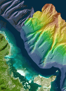
Credit: University of Hawai‘i at Mānoa.
The scientists evaluated and mapped landscape metrics of each canyon habitat, including the roughness of the seafloor and the steepness of canyon walls. At depths of 350, 650, and 1,000 meters in each location, they collected sediment core samples on the canyon floor. From these samples, they carefully sorted out and identified all of the marine organisms called macrobenthos—including worms, clams and shrimp-like crutaceans— that range in size from a millimeter to several centimeters. The scientists then correlated the macrobenthos species data with the landscape metrics.

One thing that became evident from this study was that canyons near the main Hawaiian islands tended to collect and hold much more land-based organic matter than canyons in the Northwestern Hawaiian Islands. Materials such as branches, leaves, nuts and algae were abundant off Moloka‘i and O‘ahu, washed into the ocean by rain and carried out deep onto the canyon floors by ocean currents. These decomposing materials, scarcer in the islands of Nihoa and Maro Reef, serve as valuable food sources for the seafloor invertebrates, themselves a food source for other, larger fish.
The scientists have already documented four new species discovered during the course of their research dives, including three new types of crustaceans. Up to 60 percent of the species that taxonomists identified in the submarine canyon seafloor samples are only recognized to the family level.
“There is room for discovery of many more new species,” De Leo said. “The deep sea fauna of Hawai‘i is poorly sampled and poorly understood. Every time we go to sea and sample a new area, it’s likely that we’ll find a new species.”
This series of dives was conducted on the Pisces IV and Pisces V manned submersibles operated by the Hawai‘i Undersea Research Laboratory (HURL). The research was conducted in partnership with Hawai‘i Pacific University and the New Zealand National Institute of Water and Atmospheric Research.
Citation: Fabio C. De Leo, E.W. Vetter, C. R. Smith, A. R. Ashley, and M. McGranaghan. Spatial scale-dependent habitat heterogeneity influences submarine canyon macrofaunal abundance and diversity off the Main and Northwest Hawaiian Islands. Deep Sea Research Part II: Topical Studies in Oceanography. 11 July 2013.
The Octopus Whisperer
August 28th, 2013By Alton Parrish.
“You are what you eat” is a truism for foodies, and also for writers—at least those who occasionally use a character’s diet as an avenue into that character’s soul. It works because often there are obvious links between who a person is and the sort of menu choices he or she makes. But can you say the same for, well—an octopus?

Credit: Southern New Hampshire University
One of the chief goals of the expedition was to gather information on not just what is eaten by the Pacific day octopus—a species that grows to around three feet across—but why. In other words, what differences exist between individual octopuses and their diets, and what might account for those differences?
The expedition’s lead scientist—Dr. Jennifer Mather of Canada’s University of Lethbridge—proposed that any differences might have much to do with personality, just as they do in people, and hence those slate-board sessions with creatures that are shy and reclusive, but also highly intelligent and intensely curious—and therefore sometimes willing to come out and take personality tests.
“The Octopus Scientists” will appear from Houghton Mifflin in 2015 as the next in a popular children’s series originated by Montgomery, “Scientists in the Field.” Each book is a sort of expedition into the soul of its animal subject—the snow leopard, for example, or the tree kangaroo, or the goliath bird-eating tarantula—but the books are as much about the scientists who study these animals: who they are and how they go about their work.
The most recent in the series, “The Tapir Scientist: Saving South America’s Largest Mammal,” appeared just last month to admiring reviews. In this book Montgomery takes her young readers to Brazil’s Pantanal, a huge expanse of marshland and subtropical forest (“The Everglades on steroids,” said Montgomery), to track one of the world’s most elusive megafauna.
The book “seamlessly blends eloquent text and vivid images to spotlight the gentle tapir and those field scientists whose lives are committed to conserve animal species for the sake of our environment and our humanity,” said Booklist. Kirkus Reviews, in a starred review, praised the book’s “lively, first-person voice” and “memorable detail.”
Montgomery has a big following among adults as well. Her memoir about the runt pig that she adopted and raised, “The Good, Good Pig” (Ballantine, 2007), hit the New York Times bestseller list. She is also the author more recently of “Birdology” (Simon & Schuster 2011) and “Journey of the Pink Dolphin” (Chelsea Green 2009).
Another work-in-progress is a much longer book about octopuses for adults, a book that begins with a giant Pacific octopus Montgomery met at the New England Aquarium in 2011. Her readers will make the acquaintance of octopuses in aquaria on both coasts, sit in on interviews with octopus experts from around the world, and go scuba diving for a week off Mexico. “The Soul of the Octopus” will be published simultaneously with its children’s companion by Simon & Schuster in 2015.
In the waters off Moorea, the octopus scientists, as well as Montgomery, collected shells and crab carapaces from outside lairs and went swimming with octopuses on the hunt. Dr. Mather’s hypothesis—“That bolder octopuses would be more varied in their diet,” said Montgomery, “like someone who samples every restaurant in a city”—was just one of the theories tested about octopus behavior, habitat, and personality.
But the mere fact of personality in these invertebrates came as no surprise to Montgomery. “At the Seattle Aquarium there was a very shy octopus who hardly ever came out of her lair named Emily Dickinson,” she said. “Then there’s the one who likes to put his suckers all over you. He was called Leisure Suit Larry.”
In Moorea, for the first time, Montgomery was able to interact with wild octopuses. There she fell even more deeply in love with this other sort of intelligence: creatures who use skin color both to disappear into the background and to express emotion; who have been seen lifting scallop shells in front of their lairs in defense against marauding sharks; who seem to occasionally keep crabs or catfish as pets.
“We really know so little about these guys, but they’re just amazing,” Montgomery said. “You can watch an octopus extend one arm into a hole on a coral reef, looking something to eat, and in its eyes you can see the same expression that a person assumes fishing for a set of keys in her pocket. It’s just so cool.”
Diane Les Becquets, novelist and director of the MFA writing program at Southern New Hampshire University, is proud to include Montgomery among the menu of her faculty members. “We have a strong environmental nonfiction track in our program,” she said, “and having as an affiliate a writer of Sy’s skill, stature, and passion lends that track a unique sort of breadth. She’s also just simply an inspiration to us all.
Richard Adams Carey
Assistant Director, MFA in Fiction and Nonfiction
Southern New Hampshire University
Archaeologists Discover Lost Language More Than 2,500 Years Old
August 27th, 2013By University of Cambridge.

Credit: Cambridge University/ John MacGinnis
Researchers working at Ziyaret Tepe, the probable site of the ancient Assyrian city of Tušhan, believe that the language may have been spoken by deportees originally from the Zagros Mountains, on the border of modern-day Iran and Iraq.
In keeping with a policy widely practised across the Assyrian Empire, these people may have been forcibly moved from their homeland and resettled in what is now south-east Turkey, where they would have been set to work building the new frontier city and farming its hinterland.
The evidence for the language they spoke comes from a single clay tablet, which was preserved after it was baked in a fire that destroyed the palace in Tušhan at some point around the end of the 8thcentury BCE. Inscribed with cuneiform characters, the tablet is essentially a list of the names of women who were attached to the palace and the local Assyrian administration.
Writing in the new issue of the Journal Of Near Eastern Studies, Dr John MacGinnis, from the McDonald Institute for Archaeological Research, University of Cambridge, explains how the nature of these names has piqued the interest of researchers.
“Altogether around 60 names are preserved,” MacGinnis said. “One or two are actually Assyrian and a few more may belong to other known languages of the period, such as Luwian or Hurrian, but the great majority belong to a previously unidentified language.”
“If the theory that the speakers of this language came from western Iran is correct, then there is the potential here to complete the picture of the world’s first multi-ethnic empire. We know from existing texts that the Assyrians did conquer people from that region. Now we know that there is another language, perhaps from the same area, and maybe more evidence of its existence waiting to be discovered.”
Ziyaret Tepe is on the River Tigris in south east Turkey, and has been the subject of extensive archaeological excavations since 1997. Recent work has revealed evidence that it was probably once the site of the Assyrian frontier city of Tušhan. In particular, it is thought that the remains of a monumental building excavated on the site are those of the governor’s palace, built by the Assyrian King Ashurnasirpal II (883 – 859 BCE).
The tablet was found in what may have been the palace’s throne room by Dr Dirk Wicke of the University of Mainz, working as part of a team led by Professor Timothy Matney of the University Akron, Ohio. When a conflagration destroyed the palace, perhaps around the year 700 BCE, the tablet was baked and much of its contents on the obverse side preserved.
MacGinnis was handed the task of deciphering the tablet and has identified a total of 144 names, of which 59 can still be made out. His analysis systematically rules out not only common languages from within the Assyrian Empire, but also other languages of the time – including Egyptian, Elamite, Urartian or West Semitic. Even at its most generous, his assessment suggests that only 15 of the legible names belong to a language previously known to historians.
The report also posits several theories about where this mysterious language may have come from. One notion is that it may be Shubrian – the indigenous language spoken in the Tušhan area before the Assyrians arrived. As far as historians know, Shubrian was never written down. In addition, it is believed to have been a dialect of Hurrian, which is known and does not appear to bear any resemblance to most of the names on the tablet.
Another theory is that it was the language spoken by the Mushki – a people who were migrating to Eastern Anatolia at around the time the tablet was made. This idea seems less plausible, however, as to appear on the list of the Assyrian administration, these people would either have infiltrated the Empire or been captured, and historians have evidence for neither.
More convincing is the theory that the language in question may have been spoken by a people from somewhere else in the Assyrian Empire who were forcibly moved by the administration.
This was standard practice for successive Assyrian Kings, particularly after the Empire began to expand during the 9thcentury. “It was an approach which helped them to consolidate power by breaking the control of the ruling elite in newly-conquered areas,” MacGinnis said. “If people were deported to a new location, they were entirely dependent on the Assyrian administration for their well-being.”
Although historians already know that the Zagros Mountains were in a region invaded and annexed by the Assyrians, it remains, to date, the one area under Assyrian occupation for which no known language exists. That makes it tempting to link the text on the tablet to the same region. An Assyrian King, Esarhaddon, even referred to an unidentified language, Mekhranian, which supposedly hailed from the Zagros, but in practice the area was probably a patchwork of chiefdoms and more than one dialect may have been in use.
“If correct this suggests that Iran was home to previously unknown languages,” MacGinnis said. “The immediate impression is that the names on this tablet were those of women who belonged to an isolated community. It may be, however, that there were others whom we still have to find out about.”
The tablet is currently being stored in Diyarbakir, Turkey, where it is hoped that it will eventually go on public display. Dr MacGinnis’ report on its decipherment is published in the April issue of the Journal of Near Eastern Studies.
Contacts and sources:
Cambridge University
Mysterious Magnetar Reveals One Of The Strongest Magnetic Fields In The Universe
August 26th, 2013By European Space Station.

Credit: ESA
SGR 0418 lies in our galaxy, about 6500 light years from Earth. It was first detected in June 2009 by space telescopes including NASA’s Fermi and Roscosmos’ Koronas-Photon when it suddenly lit up in X-rays and soft gamma rays. It has been studied subsequently by a fleet of observatories, including ESA’s XMM-Newton.
“Until very recently, all indications were that this magnetar had one of the weakest surface magnetic fields known; at 6 x 10¹² Gauss, it was roughly a 100 times lower than for typical magnetars,” said Andrea Tiengo of the Istituto Universitario di Studi Superiori, Pavia, Italy, and lead author of the paper published in Nature.
“Understanding these results was a challenge. However, we suspected that SGR 0418 was in fact hiding a much stronger magnetic field, out of reach of our usual analytical techniques.”
Magnetars spin more slowly than neutron stars, but still complete a rotation within a few seconds. The normal way of determining the magnetic field of a magnetar is to measure the rate at which the spin is declining. Three years of observations of SGR 0418 had led astronomers to infer a weak magnetic field.
The new technique developed by Dr Tiengo and his collaborators involves searching for variations in the X-ray spectrum of the magnetar over extremely short time intervals as it rotates. This method allows astronomers to analyse the magnetic field in much more detail and has revealed SGR 0418 as a true magnetic monster.
“To explain our observations, this magnetar must have a super-strong, twisted magnetic field reaching 1015 Gauss across small regions on the surface, spanning only a few hundred metres across,” said Dr Tiengo.
“On average, the field can appear fairly weak, as earlier results have suggested. But we are now able to probe sub-structure on the surface and see that the field is very strong locally.”
A simple analogy can be made with localised magnetic fields anchored in sunspots on the Sun, where a change in configuration can suddenly lead to their collapse and the production of a flare or, in the case of SGR 0418, a burst of X-rays.
“The spectral data provided by XMM-Newton, combined with a new way of analysing the data, allowed us to finally make the first detailed measurements of the magnetic field of a magnetar, confirming it as one of the largest values ever measured in the Universe,” adds Norbert Schartel, ESA’s XMM-Newton Project Scientist.
“We now have a new tool to probe the magnetic fields of other magnetars, which will help constrain models of these exotic objects.”
NASA Reveals Plans To Capture An Asteroid And Redirect Its Path
August 24th, 2013By Nasa.

Concept animation showing the crew operations on NASA’s proposed Asteroid Redirect Mission.

Image Credit: NASA
In late July, NASA conducted its asteroid mission formulation review, which brought together agency leaders from across the country to examine internal studies proposing multiple concepts and alternatives for each phase of the mission, and assessed technical and programmatic aspects of the mission. Currently, NASA is assessing the more than 400 responses received to a request for information in which industry, universities and the public offered ideas for the initiative.

Credit; NASA
This concept image shows an astronaut preparing to take samples from the captured asteroid after it has been relocated to a stable orbit in the Earth-moon system. Hundreds of rings are affixed to the asteroid capture bag, helping the astronaut carefully navigate the surface.

Image Credit: NASA

Research Unearths Terrace Farming At Ancient Desert City Of Petra
August 22nd, 2013By Alton Parrish.
A team of international archaeologists including Christian Cloke of the University of Cincinnati is providing new insights into successful and extensive water management and agricultural production in and around the ancient desert city of Petra, located in present-day Jordan. Ongoing investigations, of which Cloke is a part, are led by Professor Susan Alcock of the Brown University Petra Archaeological Project (BUPAP).
Using a variety of tools and techniques, including high-resolution satellite imagery and optically stimulated luminescence (OSL) dating of soils, Cloke, a doctoral student in the Department of Classics at UC, and Cecelia Feldman, classics lecturer at UMass-Amherst, have suggested that extensive terrace farming and dam construction in the region north of the city began around the first century, some 2,000 years ago, not during the Iron Age (c. 1200-300 BC) as had been previously hypothesized. This striking development, it seems, was due to the ingenuity and enterprise of the ancient Nabataeans, whose prosperous kingdom had its capital at Petra until the beginning of the second century.
Credit: University of Cincinnati
Cloke and Feldman will present their findings Jan. 4 at the Archaeological Institute of America Annual Meeting in Seattle, in a paper titled “On the Rocks: Landscape Modification and Archaeological Features in Petra’s Hinterland.” Their research efforts are contributing to a growing understanding of the city, its road networks, and life in the surrounding area.
AGRICULTURAL SUCCESS FOLLOWED BY ANNEXATION
He explained, “No doubt the explosion of agricultural activity in the first century and the increased wealth that resulted from the wine and oil production made Petra an exceptionally attractive prize for Rome. The region around Petra not only grew enough food to meet its own needs, but also would have been able to provide olives, olive oil, grapes and wine for trade. This robust agricultural production would have made the region a valuable asset for supplying Roman forces on the empire’s eastern frontier.”
Credit: University of Cincinnati
In other words, said Feldman, successful terrace farming and water management when Petra was at its zenith as a trading center added not only to the city’s economic importance but to its strategic military value as well, because there were limited options in the region for supplying troops with essential supplies.
TERRACES FOR FARMING AND DAMS FOR WATER MANAGEMENT
Rainfall in the region occurs only between October and March, often in brief, torrential downpours, so it was important for Petra’s inhabitants to capture and store all available water for later use during the dry season. Over the centuries, the Nabataeans of Petra became experts at doing so. The broad watershed of sandstone hills naturally directed water flow to the city center, and a complex system of pipes and channels directed it to underground cisterns where it was stored for later use.
“Perhaps most significantly,” said Cloke, “it’s clear that they had considerable knowledge of their surrounding topography and climate. The Nabataeans differentiated watersheds and the zones of use for water: water collected and stored in the city itself was not cannibalized for agricultural uses. The city’s administrators clearly distinguished water serving the city’s needs from water to be redirected and accumulated for nurturing crops. Thus, extensive farming activity was almost entirely outside the bounds of the city’s natural catchment area and utilized separate watersheds and systems of runoff.”
These initial conclusions from the first three seasons of BUPAP fieldwork promise more exciting discoveries about how the inhabitants of Petra cultivated the outlying landscape and supported the city’s population. The presence of highly developed systems of landscape modification and water management at Petra take on broader significance as they offer insight into geopolitical changes and Roman imperialism.
Credit: University of Cincinnati
RESEARCH SUPPORT
Two Coronal Mass Ejections Headed Towards Earth
August 22nd, 2013By NOAA.
On August 21, 2013 at 1:24 am EDT, the sun erupted with an Earth-directed coronal mass ejection, or CME, a solar phenomenon that can send billions of tons of particles into space and reach Earth one to three days later. These particles cannot travel through the atmosphere to harm humans on Earth, but they can affect electronic systems in satellites and on the ground.

Earth-directed CMEs can cause a space weather phenomenon called a geomagnetic storm, which occurs when they funnel energy into Earth’s magnetic envelope, the magnetosphere, for an extended period of time. The CME’s magnetic fields peel back the outermost layers of Earth’s fields changing their very shape. In the past, geomagnetic storms caused by CMEs of this strength have usually been mild.
Magnetic storms can degrade communication signals, cause unexpected electrical surges in power grids, and produce aurora at higher latitudes.
On August 20, 2013 at 4:24 am EDT, the sun erupted with an Earth-directed coronal mass ejection or CME, a solar phenomenon which can send billions of tons of particles into space that can reach Earth one to three days later. These particles cannot travel through the atmosphere to harm humans on Earth, but they can affect electronic systems in satellites and on the ground.
The SOHO LASCO C2 instrument captured this image of the Earth-directed CME. SOHO’s coronographs are able to take images of the solar corona by blocking the light coming directly from the Sun with an occulter disk. The location of the actual sun is shown with an image taken by SDO.

Image Credit: ESA & NASA/SOHO, SDO
Experimental NASA research models, based on observations from NASA’s Solar Terrestrial Relations Observatory show that the CME left the sun at speeds of around 570 miles per second, which is a fairly typical speed for CMEs.
Earth-directed CMEs can cause a space weather phenomenon called a geomagnetic storm, which occurs when they funnel energy into Earth’s magnetic envelope, the magnetosphere, for an extended period of time. The CME’s magnetic fields peel back the outermost layers of Earth’s fields changing their very shape. In the past, geomagnetic storms caused by CMEs of this strength have usually been mild.
The SOHO LASCO C3 instrument captured this coronographic image of the Earth-directed CME. The bright white object to the right is the planet Mercury.

Image Credit: ESA & NASA/SOHO
Magnetic storms can degrade communication signals and cause unexpected electrical surges in power grids. They also can cause aurora.
NOAA’s Space Weather Prediction Center (http://swpc.noaa.gov) is the U.S. government’s official source for space weather forecasts, alerts, watches and warnings.