


Posts by AltonParrish:
- Paul Revere’s Ride – The stuff of American legend and the subject of an oft-recited poem, Paul Revere’s midnight ride would have been rendered unnecessary in a world with internet access. The ability to spread the news of the approaching British via the web would have made quick work of the task, leaving an American icon to languish in obscurity.
- Gutenberg’s Printing Press – Had the internet existed in the lifetime of printing press inventor Johannes Gutenberg, people would never have known the experience of holding a printed, bound book. Storing text online would have precluded the need for the then-laborious process.
- The Renaissance – Many of humanity’s most cherished art, ideas and philosophies were born during the Renaissance, when the fall of the Roman Empire led to a time of lost knowledge, superstition and fear. If the Romans had been able to record their advances on a worldwide database, the information would have been preserved even after the collapse of their civilization. There would have been no need for a rebirth.
- The Discovery of America – In a world with Google Maps, Christopher Columbus would have been able to chart an accurate route to Asia, while GPS technology kept him from straying off course. His accidental discovery of The New World would have been prevented.
- The Journey of the Bible – Arguably one of the most influential and controversial texts in human history, the Christian Bible as we know it would not exist if the internet had been in place during the life of Jesus. The King James version would never have been created, and records of the earliest testaments would have been preserved in their original language.
- The Bubonic Plague – Carried by rats and infected sailors from Asia to Europe, the Bubonic plague eventually killed an estimated 60% of the European population. Internet access would have drastically lowered those numbers as news of the illness would have spread quickly and those who were exposed quarantined.
- The Mystery of Stonehenge – Despite being one of the world’s most recognizable structures, the origin and purpose of Stonehenge has been debated for centuries. The internet would have made it possible for the ancient motives of builders to be preserved, thus eliminating hundreds of years’ worth of conjecture.
- The Disappearance of Amelia Earhart – The inaccuracy of radio direction as a navigation tool for early flight has often been blamed for the loss of Amelia Earhart’s plane. Having the tools of the internet at her disposal might have led to a successful flight; had the plane still been lost, GPS systems would have aided in the craft’s recovery.
- The Failure of the Jacobite Uprising – When Bonnie Prince Charlie led his men into battle at Culloden, the results were disastrous. Too few soldiers, too little food and and a lack of sleep all contributed to the Rebellion’s defeat, but things might have ended differently if they’d been able to rally more troops by using the internet and to inform suppporters that they were in need of food and shelter. The failed rebellion left surviving soldiers imprisoned and their culture systematically destroyed.
- The Destruction of the Library of Alexandria – The Library of Alexandria was the largest, most significant library in the world; the loss of the knowledge it contained was a significant blow to many cultures. If the internet had existed in ancient Egypt, that treasure trove of information would have been preserved despite the destruction of the building; backed up files and storage systems would have left the ruined building a tragedy in the architectural realm, but a mere blip in the world of education and intellectual pursuits.
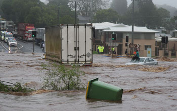
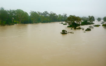
Global Sea Level Rise Temporarily Dampened By 2010-11 Australia Floods
August 20th, 2013
By Alton Parrish.
Unlike other continents, the soils and topography of Australia prevent almost all its precipitation from flowing into the ocean.
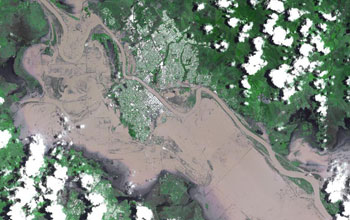
Credit: NASA
The 2010-11 event temporarily halted a long-term trend of rising sea levels caused by higher temperatures and melting ice sheets, according to a team of researchers at the National Center for Atmospheric Research (NCAR) in Boulder, Colo., and other institutions.
Now that the atmosphere’s circulation has returned to its previous patterns, the seas are again rising.
These results will appear next month in the journal Geophysical Research Letters, published by the American Geophysical Union.
Australia’s Fitzroy River in January 2011; its flooding isolated the city of Rockhampton, as shown in a satellite photo.

Credit: NASA
Co-authors of the paper are affiliated with NASA’s Jet Propulsion Laboratory and the University of Colorado at Boulder.
The research was funded by the National Science Foundation (NSF), which sponsors NCAR, and by NASA.
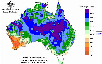
“The scientists conclude that the Outback region in Australia played a crucial role in trapping a large amount of rainfall when widespread floods occurred over the continent,” says Anjuli Bamzai, program director in NSF’s Division of Atmospheric and Geospace Sciences, which funded the research.
Credit: Government of Australia
“It’s a beautiful illustration of how complicated our climate system is,” says NCAR scientist John Fasullo, lead scientist on the project.
“The smallest continent in the world can affect sea level worldwide. Its influence is so strong that it can temporarily overcome the background trend of rising sea levels we see with climate change.”
As the climate warms, the world’s oceans have been rising in recent decades by just over three millimeters annually.
This is partly because heat causes water to expand, and partly because runoff from retreating glaciers and ice sheets is making its way into the oceans.
But for an 18-month period beginning in 2010, the oceans mysteriously dropped by about seven millimeters, more than offsetting the annual rise.
Fasullo and co-authors published research results last year demonstrating that the reason was related to the increased rainfall over tropical continents.
They also showed that the drop coincided with the atmospheric oscillation known as La Niña, which cooled tropical surface waters in the eastern Pacific and suppressed rainfall there–while enhancing it over portions of the tropical Pacific, Africa, South America and Australia.
Credit: Government of Australia
However, an analysis of the historical record showed that past La Niña events only rarely accompanied such a pronounced drop in sea level.
Using a combination of satellite instruments and other tools, the new study finds that the picture in 2010-11 was uniquely complex.
In addition to La Nina, a rare combination of two other semi-cyclic climate modes came together. They drove such large amounts of rain over Australia that the continent received almost one foot (300 millimeters) of rain more than average.
The initial effects of La Niña were to cool surface waters in the eastern Pacific Ocean and push moisture to the west.
A climate pattern known as the Southern Annular Mode then coaxed the moisture into Australia’s interior, causing widespread flooding across the continent.
Later in the event, high levels of moisture from the Indian Ocean driven by what’s known as the Indian Ocean Dipole collided with La Niña-borne moisture in the Pacific, pushing even more moisture into the continent’s interior.
Credit: Government of Australia
These influences spurred one of the wettest periods in Australia’s recorded history.
Australia’s vast interior, called the Outback, is ringed by coastal mountains and is often quite dry.
Because of the low-lying nature of the continent’s eastern interior, and the lack of river runoff in its western dry environment, most of the heavy rainfall of 2010-11 remained inland rather than flowing to the oceans.
While some of it evaporated in the desert sun, much of it sank into the dry, granular soil of the Western Plateau or filled the Lake Eyre basin in the east.
“No other continent has this combination of atmospheric set-up and topography,” Fasullo says. “Only in Australia could the atmosphere carry such heavy tropical rains to such a large area, only to have those rains fail to make their way to the ocean.”
For example, the Great Basin in the southwestern United States could trap water much like Australia–but atmospheric patterns don’t transport such a large amount of moisture from the ocean to that arid region.
To conduct the research, the scientists turned to three observing instrument systems:
· NASA’s Gravity Recovery and Climate Experiment satellites, which make detailed measurements of Earth’s gravity field. The satellites enable scientists to monitor changes in the mass of continents.
· The Argo global array of 3,000 free-drifting floats that measure the temperature and salinity of the upper 6,000 feet of the world’s oceans.
· Satellite-based altimeters that are continuously calibrated against a network of tide gauges. Scientists subtract seasonal and other variations to closely estimate global sea level changes.
Using these instruments, the researchers found that the land mass in Australia and, to a lesser extent, South America began to increase in 2010 as the continents experienced heavy and persistent rain.
At the same time, sea levels began to drop.
Since 2011, when the atmospheric patterns shifted out of their unusual combination, sea levels have been rising at a faster pace of about 10 millimeters per year.
Scientists are uncertain how often the three atmospheric events come together to cause such heavy rains over Australia.
Fasullo believes there may have been a similar event in 1973-74, which was another time of record flooding.
But modern observing instruments did not exist then, making it impossible to determine what took place in the atmosphere and whether it affected sea level rise.
“Luckily we’ve got great observations now,” Fasullo says. “We need to maintain these observing platforms to understand our climate system.”
Nevada Petroglyphs Could Be 14,800 Years Old, America’s Oldest Art
August 18th, 2013Nevada Petroglyphs Could Be 14,800 Years Old, America’s Oldest Art

Credit: University of Colorado
Benson and his colleagues used several methods to date the petroglyphs, including determining when the water level the Winnemucca Lake subbasin—which back then was a single body of water connecting the now-dry Winnemucca Lake and the existing Pyramid Lake—reached the specific elevation of 3,960 feet.
The elevation was key to the study because it marked the maximum height the ancient lake system could have reached before it began spilling excess water over Emerson Pass to the north. When the lake level was at this height, the petroglyph-peppered boulders were submerged and therefore not accessible for carving, said Benson, an adjunct curator of anthropology at the University of Colorado Museum of Natural History.
A paper on the subject was published this month in the Journal of Archaeological Science. Co-authors on the study included Eugene Hattori of the Nevada State Museum in Carson City, Nev., John Southon of the University of California, Irvine and Benjamin Aleck of the Pyramid Lake Paiute Tribe Museum and Visitor’s Center in Nixon, Nev. The National Research Program of the U.S. Geological Survey funded the study.
According to Benson, a white layer of carbonate made of limestone precipitated from the ancient, overflowing Winnemucca Lake had coated some of the petroglyph carvings near the base of the boulders. Previous work by Benson showed the carbonate coating elsewhere in the basin at that elevation had a radiocarbon date of roughly 11,000 years ago.
Benson sampled the carbonate into which the petroglyphs were incised and the carbonate that coated the petroglyphs at the base of the limestone boulder. The radiocarbon dates on the samples indicated the carbonate layer underlying the petroglyphs dated to roughly 14,800 ago. Those dates, as well as additional geochemical data on a sediment core from the adjacent Pyramid Lake subbasin, indicated the limestone boulders containing the petroglyphs were exposed to air between 14,800 and 13,200 years ago and again between about 11,300 and 10,500 years ago.
“Prior to our study, archaeologists had suggested these petroglyphs were extremely old,” said Benson, also an emeritus USGS scientist. “Whether they turn out to be as old as 14,800 years ago or as recent as 10,500 years ago, they are still the oldest petroglyphs that have been dated in North America.”
While Native American artifacts found in the Lahontan Basin—which encompasses the Winnemucca Lake subbasin—date to the time period of 11,300 to 10,500 years ago, it does not rule out the possibility that the petroglyphs were carved as early as 14,800 years ago, Benson said.
The oldest dates calculated for the Winnemucca Lake petroglyph site correspond with the time frame linked to several pieces of fossilized human excrement found in a cave in Oregon, said Benson, who also is affiliated with CU’s Institute of Arctic and Alpine Research. The caves, known as the Paisley Caves in south central Oregon, held not only fossilized human coprolites that dated to roughly 14,400 years ago, but also bones of horses and camels that went extinct in North America prior to 13,000 years ago.
The younger time interval calculated for the Winnemucca petroglyphs corresponds to dates obtained from a second significant archaeological finding in the region—Spirit Cave Man, who was discovered more than 70 years ago some 60 miles east of Reno and whose hair, bones and clothing were dated to about 10,600 years ago. The remains of the man, who was found partially mummified in a shallow grave in Spirit Cave, Nevada, were discovered with a fur robe, a woven marsh plant shroud and moccasins.
Petroglyphs near Long Lake in central Oregon—which were previously thought to be the oldest examples of rock art in North America—share similar features with some of the rock art the Winnemucca site, said Benson. At least one of the petroglyph panels from Long Lake was buried by ash from an eruption of the nearby Mount Mazama volcano roughly 6,700 years ago, proof that it was carved sometime before the eruption.
“We have no idea what they mean,” Benson said of the Winnemucca Lake petroglyphs. “But I think they are absolutely beautiful symbols. Some look like multiple connected sets of diamonds, and some look like trees, or veins in a leaf. There are few petroglyphs in the American Southwest that are as deeply carved as these, and few that have the same sense of size.”
Benson obtained permission to non-invasively examine the petroglyphs from the Pyramid Lake Paiute Tribe, which owns the land. Study co-author John Southton, a faculty member at University of California, Irvine, radiocarbon dated the material for the study.
Soft Drinks Changing Behaviour – Associated With Aggression, Depression And Suicidal Thoughts In Adolescents
August 18th, 2013By Columbia University.

Shakira Suglia, ScD, Mailman School assistant professor of Epidemiology, and colleagues assessed approximately 3,000 5-year-old children enrolled in the Fragile Families and Child Wellbeing Study, a prospective birth cohort that follows mother-child pairs from 20 large U.S. cities. Mothers reported their child’s soft drink consumption and completed the Child Behavior Checklist based on their child’s behavior during the previous two months. The researchers found that 43% of the children consumed at least 1 serving of soft drinks per day, and 4% consumed 4 or more.
Aggression, withdrawal, and attention problems were associated with soda consumption. Even after adjusting for sociodemographic factors, maternal depression, intimate partner violence, and paternal incarceration, any soft drink consumption was associated with increased aggressive behavior. Children who drank 4 or more soft drinks per day were more than twice as likely to destroy things belonging to others, get into fights, and physically attack people. They also had increased attention problems and withdrawal behavior compared with those who did not consume soft drinks.
“We found that the child’s aggressive behavior score increased with every increase in soft drinks servings per day,” said Dr. Suglia. Although this study cannot identify the exact nature of the association between soft drink consumption and problem behaviors, limiting or eliminating a child’s soft drink consumption may reduce behavioral problems.
Castles In The Desert – Satellites Reveal Lost Cities Of Libya
August 16th, 2013By University of Leicester.
This is a photo of the mudbrick village with castle like structure visible in the center of the image.

Credit: Photo by Toby Savage.
Satellite imagery has uncovered new evidence of a lost civilization of the Sahara in Libya’s south-western desert wastes that will help re-write the history of the country.
The fall of Gaddafi has opened the way for archaeologists to explore the country’s pre-Islamic heritage, so long ignored under his regime.
Using satellites and air-photographs to identify the remains in one of the most inhospitable parts of the desert, a British team has discovered more than 100 fortified farms and villages with castle-like structures and several towns, most dating between AD 1-500.
These “lost cities” were built by a little-known ancient civilisation called the Garamantes, whose lifestyle and culture was far more advanced and historically significant than the ancient sources suggested.
The team from the University of Leicester has identified the mud brick remains of the castle-like complexes, with walls still standing up to four metres high, along with traces of dwellings, cairn cemeteries, associated field systems, wells and sophisticated irrigation systems. Follow-up ground survey earlier this year confirmed the pre-Islamic date and remarkable preservation.
![]()
This is a satellite image of area of desert with archaeological interpretation of features: fortifications are outlined in black, areas of dwellings are in red and oasis gardens are in green.

Credit: Copyright 2011 Google, image copyright 2011 DigitalGlobe.
“It is like someone coming to England and suddenly discovering all the medieval castles. These settlements had been unremarked and unrecorded under the Gaddafi regime,” says the project leader David Mattingly FBA, Professor of Roman Archaeology at the University of Leicester.
“Satellite imagery has given us the ability to cover a large region. The evidence suggests that the climate has not changed over the years and we can see that this inhospitable landscape with zero rainfall was once very densely built up and cultivated. These are quite exceptional ancient landscapes, both in terms of the range of features and the quality of preservation,” says Dr Martin Sterry, also of the University of Leicester, who has been responsible for much of the image analysis and site interpretation.
The findings challenge a view dating back to Roman accounts that the Garamantes consisted of barbaric nomads and troublemakers on the edge of the Roman Empire.
“In fact, they were highly civilised, living in large-scale fortified settlements, predominantly as oasis farmers. It was an organised state with towns and villages, a written language and state of the art technologies. The Garamantes were pioneers in establishing oases and opening up Trans-Saharan trade,” Professor Mattingly said.
![]()

Credit: Photo by Toby Savage ![]()
![]()
The professor and his team were forced to evacuate Libya in February when the anti-Gaddafi revolt started, but hope to be able to return to the field as soon as security is fully restored. The Libyan antiquities department, badly under-resourced under Gaddafi, is closely involved in the project. Funding for the research has come from the European Research Council who awarded Professor Mattingly an ERC Advanced Grant of nearly 2.5m euros, the Leverhulme Trust, the Society for Libyan Studies and the GeoEye Foundation.
“It is a new start for Libya’s antiquities service and a chance for the Libyan people to engage with their own long-suppressed history,” says Professor Mattingly.
“These represent the first towns in Libya that weren’t the colonial imposition of Mediterranean people such as the Greeks and Romans. The Garamantes should be central to what Libyan school children learn about their history and heritage.”
CSIRO Scientists Show Planet Nibiru Doesn’t Exist: Pulsars Make A GPS For The Cosmos
August 16th, 2013By CSIRO.
Navigating with pulsars is ideal for spacecraft going beyond our solar system. Voyager 1, shown here, is now more than 18 billion kilometres from Earth and heading into interstellar space. 

“If the telescopes were on board a spacecraft, then we could get the position of the spacecraft.”
Observations of at least four pulsars, every seven days, would be required. “Each pulsar would have to be observed for about an hour,” Dr Hobbs said. “Whether you can do them all at the same time or have to do them one after the other depends on where they are and exactly what kind of detector you use.”
A paper describing in detail how the system would work has been accepted for publication by the journal Advances in Space Research.
Spacecraft within the solar system are usually tracked and guided from the ground: this is the role of CSIRO’s Canberra Deep Space Communication Complex, for instance. But the further out the craft go, the less accurately we can measure their locations.
For voyages beyond the solar system, spacecraft would need an on-board (‘autonomous’) system for navigation. Gyroscopes and accelerometers are useful tools, but the position information they give becomes less accurate over time.
“Navigating with pulsars avoids these problems,” said Deng Xinping, a PhD student at the National Space Science Center in Beijing who is the first author on the paper describing the system.
Scientists proposed pulsar navigation as early as 1974. Putting it into practice has recently come closer, with the development of fairly small, lightweight X-ray detectors that could receive the X-ray pulses that certain pulsars emit. NASA is exploring the technique.
“For deep-space navigation, we would use pulsars that had been observed for many years with radio telescopes such as Parkes, so that the timing of their pulses is very well measured,” said CSIRO’s Dr Dick Manchester, a member of the research team. “Then on board the spacecraft you’d use an X-ray telescope, which is much smaller and lighter.”
Dr Hobbs and his colleagues have made a very detailed simulation of a spacecraft navigating autonomously to Mars using this combination of technologies and their TEMPO2 software.
“The spacecraft can determine its position to within about 20 km, and its velocity to within 10 cm per second,” said Dr Hobbs. “To our knowledge, this is the best accuracy anyone has ever been able to demonstrate.”
“Unlike previous work, we’ve taken into account that real pulsars are not quite perfect, they have timing glitches and so on. We’ve allowed for that.”
The same pulsar software can be used to work out the masses of objects in the solar system.
In 2010 Dr Hobbs and his colleagues used an earlier version of the software to ‘weigh’ the planets out as far as Saturn — to six decimal places.
The Earth is travelling around the Sun, and this movement affects exactly when pulsar signals arrive here. To remove this effect, astronomers calculate when the pulses would have arrived at the Solar System’s centre of mass, around which all the planets orbit.
“If the pulsar signals appear to be coming in at the wrong time, we know that the masses of the planets that we are using in the equations must be wrong, and we can correct for this,” Dr Hobbs explained.
The new version of the software lets the astronomers rule out unseen masses, including any supposedly undiscovered planets, such as the notorious Nibiru.
“Even if a planet is hard to see, there’s no way to disguise its gravitational pull,” Dr Hobbs said. “If we don’t detect the gravitational pull, then there’s no planet there. Full stop.”
And what about showing that the Earth goes around the Sun? Yes, they can do that too.
“This was nailed a couple of hundred years ago,” said Dr Hobbs. “But if you still need proof, we’ve got it.”
Origin of Stone Tool Sharpening Pushed Back More Than 50,000 Years With Discovery of Blombos Point
August 14th, 2013By University of Colorado Boulder.
Researchers discover oldest evidence of pressure flaking in South African cave. A highly skillful and delicate method of sharpening and retouching stone artifacts by prehistoric people appears to have been developed at least 75,000 years ago, more than 50,000 years earlier than previously thought, according to a new study led by the University of Colorado at Boulder.

The new findings show that the technique, known as pressure flaking, took place at Blombos Cave in South Africa during the Middle Stone Age by anatomically modern humans and involved the heating of silcrete — quartz grains cemented by silica — used to make tools. Pressure flaking takes place when implements previously shaped by hard stone hammer strikes followed by softer strikes with wood or bone hammers are carefully trimmed on the edges by directly pressing the point of a tool made of bone on the stone artifact.
The technique provides a better means of controlling the sharpness, thickness and overall shape of bifacial tools like spearheads and stone knives, said Paola Villa, a curator at the University of Colorado Museum of Natural History and a study co-author. Prior to the Blombos Cave discovery, the earliest evidence of pressure flaking was from the Upper Paleolithic Solutrean culture in France and Spain roughly 20,000 years ago.
“This finding is important because it shows that modern humans in South Africa had a sophisticated repertoire of tool-making techniques at a very early time,” said Villa. “This innovation is a clear example of a tendency to develop new functional ideas and techniques widely viewed as symptomatic of advanced, or modern, behavior.”
A paper on the subject was published in the Oct. 29 issue of Science. Other study co-authors included Vincent Mourre of the French National Institute for Preventive Archaeological Research in France and Christopher Henshilwood of the University of Bergen in Norway and director of the Blombos Cave excavation. The research was funded by the Wenner Gren Foundation of New York.
“Using the pressure flaking technique required strong hands and allowed toolmakers to exert a high degree of control on the final shape and thinness that cannot be achieved by percussion,” Villa said. “This control helped to produce narrower and sharper tool tips.” The bifacial points, known as Still Bay points, likely were spearheads, she said.
The authors speculated that the pressure flaking technique may have been invented in Africa and used sporadically before its later, widespread adoption in Europe, Australia and North America. North American archaeologists have shown that Paleoindians used the pressure flaking technique to fashion stone points likely used to hunt a menagerie of now-extinct mammals like mammoths, mastodons and ancient horses.
With the exception of obsidian, jasper and some high-quality flint, few stone materials can be pressure flaked without first heating them, Villa said. While there is evidence of silcrete heating some 164,000 years ago at the Pinnacle Point site in South Africa, the Blombos Cave artifacts are the first clear evidence of the skillful pressure flaking technique being used to carefully shape, refine and retouch tools, said Villa.
There are several ways to confirm whether silcrete has been heat-treated, Villa said. Archaeologists at Pinnacle Point used two common methods called thermoluminescence and archaeomagnetism that require the destruction of stone tool samples, as well as a non-destructive technique known as maximum gloss analysis.
Villa, Mourre and Henshilwood used a visual method for the Blombos Cave artifact analysis based on the contrast between heated and unheated tool surfaces observed microscopically at low magnification. While the removal of flakes from unheated silcrete produces scar surfaces with a rough, dull texture, heat-treated silcrete scar surfaces have a smooth, glossy appearance, said Villa.
The researchers analyzed 159 silcrete points and fragments, 179 other retouched pieces and more than 700 flakes from a layer in Blombos Cave linked to the so-called Still Bay industry, a Middle Stone Age tool manufacturing style that started roughly 76,000 years ago and which may have lasted until 72,000 years ago. The researchers concluded that at least half of the ancient, finished points at Blombos Cave were retouched by pressure flaking.
In addition to the microscopic analysis of the tools, the team also used experimental replication to show that pressure flaking was used in the final retouching phase of the points. The shaping of both heated and non-heated tools — known as knapping — was done by Mourre using silcrete chunks collected by Henshilwood from outcrops roughly 20 miles from Blombos Cave.
The silcrete samples used in the replication stage of the study were heated by Henshilwood in collaboration with Kyle Brown of Arizona State University, who published a 2009 paper in Science on the heat-treatment of silcrete in South Africa.
The team members compared attributes of points and flakes created for the experiments by percussion and pressure with points and flakes found in Blombos Cave, finding that unheated silcrete chunks first shaped with quartzite stone hammers and further worked on with wooden hammers known as billets could not be pressure flaked.
“Pressure flaking adds to the repertoire of technological advances during the Still Bay (period) and helps define it as a time when novel ideas were rapidly introduced,” wrote the authors in Science. “This flexible approach to technology may have conferred an advantage to the groups of Homo sapiens who migrated out of Africa about 60,000 years ago.”
Mind Blowing: Graphic Shows Orbits of 1,400 Potentially Hazardous Asteroids
August 14th, 2013By JPL NASA.

 Image credit: PS-1/UH
Astronomers with NASA and other organizations do track these asteroids, continually refining what we know about their orbits so that more precise predictions can be made about their future close approaches and impact probabilities.
More than 10,000 asteroids and comets that can pass near Earth have now been discovered. The 10,000th near-Earth object, asteroid 2013 MZ5, was first detected on the night of June 18, 2013, by the Pan-STARRS-1 telescope, located on the 10,000-foot (3,000-meter) summit of the Haleakala crater on Maui. Managed by the University of Hawaii, the PanSTARRS survey receives NASA funding.
Ninety-eight percent of all near-Earth objects discovered were first detected by NASA-supported surveys.
“Finding 10,000 near-Earth objects is a significant milestone,” said Lindley Johnson, program executive for NASA’s Near-Earth Object Observations Program at NASA Headquarters, Washington. “But there are at least 10 times that many more to be found before we can be assured we will have found any and all that could impact and do significant harm to the citizens of Earth.” During Johnson’s decade-long tenure, 76 percent of the NEO discoveries have been made.
Near-Earth objects (NEOs) are asteroids and comets that can approach the Earth’s orbital distance to within about 28 million miles (45 million kilometers). They range in size from as small as a few feet to as large as 25 miles (41 kilometers) for the largest near-Earth asteroid, 1036 Ganymed.
Asteroid 2013 MZ5 is approximately 1,000 feet (300 meters) across. Its orbit is well understood and will not approach close enough to Earth to be considered potentially hazardous.
“The first near-Earth object was discovered in 1898,” said Don Yeomans, long-time manager of NASA’s Near-Earth Object Program Office at the Jet Propulsion Laboratory in Pasadena, Calif. “Over the next hundred years, only about 500 had been found. But then, with the advent of NASA’s NEO Observations program in 1998, we’ve been racking them up ever since. And with new, more capable systems coming on line, we are learning even more about where the NEOs are currently in our solar system, and where they will be in the future.”
Of the 10,000 discoveries, roughly 10 percent are larger than six-tenths of a mile (one kilometer) in size – roughly the size that could produce global consequences should one impact the Earth. However, the NASA NEOO program has found that none of these larger NEOs currently pose an impact threat and probably only a few dozen more of these large NEOs remain undiscovered.
The vast majority of NEOs are smaller than one kilometer, with the number of objects of a particular size increasing as their sizes decrease. For example, there are expected to be about 15,000 NEOs that are about one-and-half football fields in size (460 feet, or 140 meters), and more than a million that are about one-third a football field in size (100 feet, or 30 meters). A NEO hitting Earth would need to be about 100 feet (30 meters) or larger to cause significant devastation in populated areas. Almost 30 percent of the 460-foot-sized NEOs have been found, but less than 1 percent of the 100-foot-sized NEOs have been detected.
When it originated, the NASA-instituted Near-Earth Object Observations Program provided support to search programs run by the Massachusetts Institute of Technology’s Lincoln Laboratory (LINEAR); the Jet Propulsion Laboratory (NEAT); the University of Arizona (Spacewatch, and later Catalina Sky Survey) and the Lowell Observatory (LONEOS). All these search teams report their observations to the Minor Planet Center, the central node where all observations from observatories worldwide are correlated with objects, and they are given unique designations and their orbits are calculated.
“When I began surveying for asteroids and comets in 1992, a near-Earth object discovery was a rare event,” said Tim Spahr, director of the Minor Planet Center. “These days we average three NEO discoveries a day, and each month the Minor Planet Center receives hundreds of thousands of observations on asteroids, including those in the main-belt. The work done by the NASA surveys, and the other international professional and amateur astronomers, to discover and track NEOs is really remarkable.”
Within a dozen years, the program achieved its goal of discovering 90 percent of near-Earth objects larger than 3,300 feet (1 kilometer) in size. In December 2005, NASA was directed by Congress to extend the search to find and catalog 90 percent of the NEOs larger than 500 feet (140 meters) in size. When this goal is achieved, the risk of an unwarned future Earth impact will be reduced to a level of only one percent when compared to pre-survey risk levels. This reduces the risk to human populations, because once an NEO threat is known well in advance, the object could be deflected with current space technologies.
Currently, the major NEO discovery teams are the Catalina Sky Survey, the University of Hawaii’s Pan-STARRS survey and the LINEAR survey. The current discovery rate of NEOs is about 1,000 per year.
NASA’s Near-Earth Object Observations Program manages and funds the search for, study of and monitoring of asteroids and comets whose orbits periodically bring them close to Earth. The Minor Planet Center is funded by NASA and hosted by the Smithsonian Astrophysical Observatory in Cambridge, MA.
Gobekli Tepe Images
August 12th, 2013By Alton Parrish.
Gobekli Tepe, the world’s oldest known temple, dating back more than 10,000 years is located near the ancient city of Şanlıurfa.
Göbekli Tepe is an early Neolithic sanctuary located at the top of a mountain ridge in the Southeastern Anatolia Region of Turkey, northeast of the town of Şanlıurfa (formerly Urfa / Edessa). It includes massive stones carved about 11,000 years ago by people who had not yet developed metal tools or even pottery
Overview of the Gobekli Tepe archaeological site.

The history of Şanlıurfa is recorded from the 4th century BC, but may date back to 9000 BC, when there is ample evidence for the surrounding sites at Duru, Harran and Nevali Cori. It was one of several cities in the Euphrates-Tigris basin, the cradle of the Mesopotamian civilization. According to Turkish Muslim traditions Urfa (its name since Byzantine days) is the biblical city of Ur of the Chaldees, due to its proximity to the biblical village of Harran. However, based on historical and archaeological evidence, the city of Ur is today generally known to have been in southern Iraq, and the true birthplace of Abraham is still in question. Urfa is also known as the birthplace of Job.
Location of Gobekli Tepe and Urfa

The tell has a height of 15 m (49 ft) and is about 300 m (984 ft) in diameter. It is approximately 760 m (2,493 ft) above sea level. It was first noted in a survey conducted by Istanbul University and the University of Chicago in 1964. The survey recognized that the rise could not entirely be a natural feature, but postulated that a Byzantine cemetery lay beneath. The survey noted a large number of flints and the presence of limestone slabs thought to be grave markers. The hill had long been under agricultural cultivation; generations of local inhabitants had frequently moved rocks and placed them in clearance piles, possibly destroying much archaeological evidence in the process.
Klaus Schmidt, chief archaeologist of Göbekli Tepe, is of the view that religion and the mobilization of labor behind the building of religious centers like Göbekli Tepe were the chief factors driving the development of civilization and the transition from the Paleolithic to the Neolithic ages

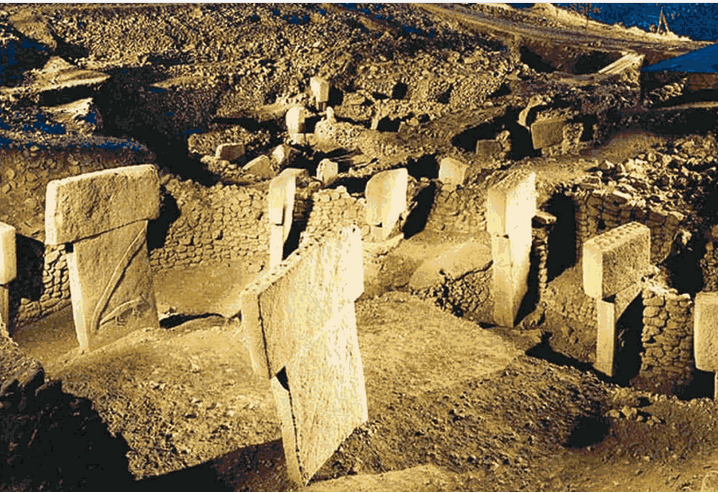
Schmidt, now of the Deutsches Archäologisches Institut, was working as part of a team at a nearby site but at the same time looking for another site to dig leading a team of his own. He reviewed the archaeological literature on the surrounding area, found the Chicago researchers’ brief description of Göbekli Tepe, and decided to give it another look. “Within minutes”, he said, he realized that the flint chips on the surface of the tell were prehistoric. The following year (1995) he began excavating there in collaboration with the Şanlıurfa Museum. T-shaped pillars were soon discovered. Some had apparently undergone attempts at smashing, probably by farmers who mistook them for ordinary large rocks.

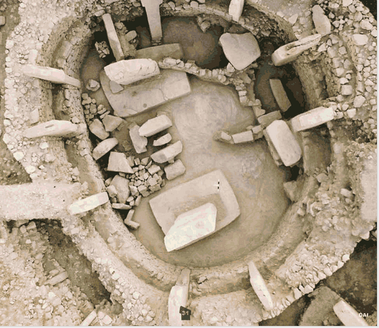
Schmidt’s view, shared by most experts, is that Göbekli Tepe is a stone-age mountain sanctuary. Radiocarbon dating as well as comparative, stylistic analysis indicate that it is the oldest religious site found to date. Schmidt believes that what he calls this “cathedral on a hill” was a pilgrimage destination attracting worshipers up to 100 miles (160 km) distant.
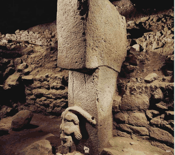
A carving of a lion and a boar on the stele at Gobekli Tepe.

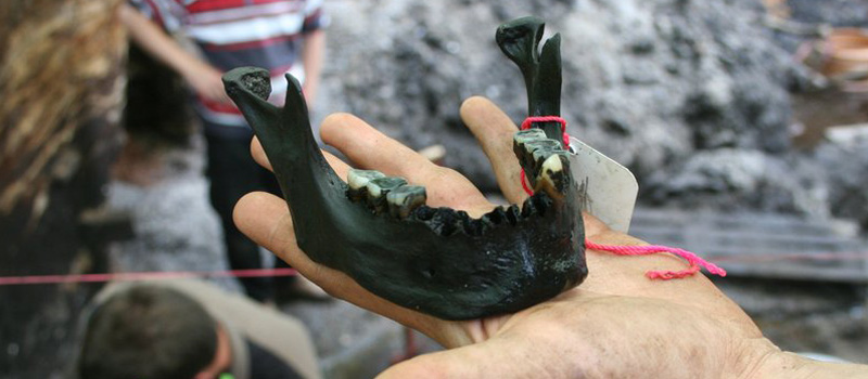
Butchered bones found in large numbers from local game such as deer, gazelle, pigs, and geese have been identified as refuse from food hunted and cooked or otherwise prepared for congregants

Göbekli Tepe is regarded as an archaeological discovery of the greatest importance since it could profoundly change the understanding of a crucial stage in the development of human society. Ian Hodder of Stanford University said, “Göbekli Tepe changes everything”.

David Lewis-Williams, professor of archaeology at Witwatersrand University in Johannesburg, has said, “Göbekli Tepe is the most important archaeological site in the world.” It shows that the erection of monumental complexes was within the capacities of hunter-gatherers and not only of sedentary farming communities as had been previously assumed. As excavator Klaus Schmidt puts it, “First came the temple, then the city.

Not only its large dimensions, but the side-by-side existence of multiple pillar shrines makes the location unique.


In 2010, Global Heritage Fund (GHF) announced it will undertake a multi-year conservation program to preserve Göbekli Tepe. Partners include Klaus Schmidt and the Deutsches Archäologisches Institut, German Research Foundation, Şanlıurfa Municipal Government, and the Turkish Ministry of Tourism and Culture.

The stated goals of the GHF Göbekli Tepe project are to support the preparation of a site management and conservation plan, construction of a shelter over the exposed archaeological features, training community members in guiding and conservation, and helping Turkish authorities secure UNESCO World Heritage Site designation for Gobekli Tepe.

One theory about Gobekli Tepe is the nearby holes were part of a scenario where statues were placed in the larger holes and small fires were lit in the small holes.”

A Layer Of Tiny Grains Can Slow Sound Waves
August 11th, 2013By Alton Parrish.

Photo courtesy of Tian Gan
A paper on the research appears in the journal Physical Review Letters, written by Nicholas Fang, the Brit and Alex d’Arbeloff Career Development Associate Professor in Engineering Design; Nicholas Boechler, a former MIT postdoc now at the University of Washington; and four co-authors.
Research on the properties of granular materials — collections of small grains, such as sand or tiny glass beads — has become “a rich and rapidly developing field,” the researchers write. But most such research has focused on the properties of sand-sized particles, about a millimeter across, Fang says. The new work is the first to examine the very different properties of particles that are about one-thousandth that size, or one micrometer across, whose properties were expected to be “qualitatively different.”
In their experiments, the team used a single layer of microspheres to guide and slow sound waves (known as surface acoustic waves, or SAWs) traveling across a surface, Fang says. The researchers used ideas they had previously applied in research on controlling light waves, he says, which involved the use of photonic crystals.
SAWs are widely used in electronic devices such as cellphones, Fang says, “like clocks that give a single frequency signal … to synchronize different chips or parts of a chip.” But with the new system, “we can shrink the device size” needed for processing SAWs, he says. Present-day oscillators for SAWs are relatively bulky, Fang says, but the use of a 2-D granular material to guide and slow the waves could allow such devices to be only one-sixth their present size, he estimates.
What’s more, the 2-D nature of this system could allow it to be fabricated right on a chip, along with the necessary control circuits and other components. Today’s oscillators, by contrast, are typically separate devices placed next to the chip array that controls them, Fang says — so in cases where small size is important, the new work has the potential to allow for even smaller electronic devices.
The system could potentially also be used to develop new kinds of sensors, such as microbalances capable of measuring tiny changes in weight, he says.
The same principle could also lead to a new kind of blast-shielding material, Fang suggests. If acoustic waves — such as the intense shock waves from an explosion — hit the two-dimensional material at a right angle, much of their energy can be converted to surface waves that travel sideways out of the material. A sandwich of many layers of such material might provide substantial protection from a blast in a lightweight, wearable form, though such applications will likely require substantial further research, Fang says.
In addition to Fang and Boechler, the research team included graduate students Jeff Eliason and Anshuman Kumar; research fellow Alex Maznev; and professor of chemistry Keith Nelson. The work was supported by the Defense Threat Reduction Agency and the National Science Foundation.
Contacts and sources:
Written by: David L. Chandler
Turning History’s ‘Lost’ Into ‘Found’
August 10th, 2013
But it’s a wonder that the document – a pictorial history-map of Santa Catarina Ixtepeji, a village in Mexico – was rediscovered at all.
The 7-foot-long painted scroll is one of the few known pictorial documents that contain text in the indigenous Zapotec language. It had been in the hands of private collectors early in the 20th century, including California mining engineer A.E. Place, who sold it to the AGS in 1917 for $350.

Fast forward to 1978. The AGS collection moved from New York to UWM, where archivists have been piecing together the stories of the more than 1 million items in the collection bit by bit over the last 34 years. The contents include maps, globes, diaries and other memorabilia gathered by the society’s member-explorers, from Charles Lindbergh to Teddy Roosevelt.
In 1995, AGSL curator Christopher Baruth came across a tattered scroll containing both writing and pictures. There were no markings on it to link it to a card in the collection’s catalog. “I had asked someone about it at that time,” he remembers, “but that person didn’t think it was anything of significance.”
That could have been the end of the story. Baruth formally retired in 2011 after 31 years with the AGSL, 16 as curator. After fielding a staff member’s question about the scroll while organizing his office, Baruth decided to get a second opinion.
Detail of the codice. In a 1917 letter to the AGS, the seller, California mining engineer A. E. Place, wrote: “Were it not for the fact that I am forging into business here, after having lost nearly all my property in Mexico, I would not sell the map at any price.”

He called Aims McGuinness, UWM associate professor of history, who could tell that the scroll was written in both Spanish and an indigenous language. To home in on its origin, McGuinness consulted with someone who specializes in colonial Latin America – and she was just downtown at Marquette University.
It takes a community
Laura Matthew, an assistant professor of history, remembers being psyched to see the “mystery document,” which, she says, recounts the history of leadership and land ownership in a specific town in Mexico. “It continued an older tradition of documents kept by royal houses that were intended to accompany an oral presentation, like a visual aid.”
The document was written in both the native and Spanish languages because it would have been used to legitimize land ownership in a bureaucratic process involving Spanish officials. Two dates inscribed on it – 1691 and 1709 – were probably the dates it was used, Matthew surmises.
Matthew is not an expert in Zapotec, but she knows someone who is. Michel Oudijk at the Universidad Nacional Autónoma de México knew exactly what the scroll was from looking at emailed photos – and he knew because he had been looking for it for more than a decade.
“That’s when we knew we had something valuable,” says Matthew. “And luck played a part, because he had already studied this type of document and that made for a fast identification.”
Oudijk and colleague Sebastián van Doesburg had found scholarly reports from the 1960s indicating two documents from Santa Catarina Ixtepeji had been sold in the early 20th century. One was sold by a British consular official in Oaxaca named Rickards, a Mexican of Scottish descent. But the research did not reveal that mining engineer Place was the buyer, or that it had ended up at the AGS.
Mystery solved
That information came some 50 years later when UWM’s Baruth consulted the last batch of archival material – 10,000 pounds of it – that arrived in Milwaukee from New York in 2010. He unearthed a letter from Place, dated 1917, stating the price he wanted for his piece of antiquity. It provided the final piece in the puzzle of how the rare scroll had found its way from Mexico to Milwaukee.
Baruth believes that Place probably secured the artifact from Rickards, as the two were both in the mining community around Oaxaca.
By the time Place wanted to sell the artifact, the AGS was preoccupied with boundary disputes in Europe as World War I drew to a close. Baruth suspects that’s why the document entered the collection with little notice. It was mostly likely shelved without sufficient identification and forgotten.
The discovery and identification of this piece illustrates the value of the work by librarians, archivists and the global community of scholars, says McGuinness.
“This is more than just a curiosity,” he says. “This document tells us in the present something about Mexico that we would not otherwise have known. So UWM and Marquette are part of a circuit that creates and disseminates information of worldwide significance.”
Collaboration extended beyond the academic. Jim DeYoung, senior conservator at the Milwaukee Art Museum, advised that the scroll never be rolled again. He designed and constructed the frame that it is now displayed in.
Through it all, McGuinness’ and Matthew’s students witnessed the mystery unfold. “This has been invaluable to teach students about the impact of research,” says McGuinness. “My students could see knowledge being produced and the cooperation among institutions that made it happen.”
Tiny Collisions Multiply Power Of Sandstorms
August 9th, 2013By Alton Parrish.

But a new study in Physical Review Letters suggests a particle’s fate depends on more than just this ground splash. A collision in midair can change an individual particle’s behavior—and the motion of the storm as a whole.
To examine the effects of these collisions, an international team of researchers created a three-dimensional computer model that incorporates the behavior of individual particles during a sandstorm, giving each particle roughly the same dimensions as a grain of sand.

Credit: Mike Olbinski
Clearly, saltons can contribute to a storm’s strength. But their creation depends on collisions with the ground, not with other airborne particles, at least according to the original model. The new study claims this picture is incorrect. To start, the reptons are actually split into two separate categories: creepers, which maintain contact with the ground, and leapers, which make small hops over the surface.
“When saltons try to come back and touch the ground, they collide with these leapers,” Araujo said. “Instead of going directly to the ground, they touch another one and another one. What we are explaining now is that saltons are created due to the history of collisions that they have in the air, not during the splash. In most cases, it’s while flying that leapers will collide with other particles and become saltons.”
In addition to including or excluding midair collisions in their sandstorm model, the researchers could also alter various properties of the simulated particles. This helped them find the factors that would maximize the flow of airborne debris.
The scientists discovered that a storm will be strongest when it’s made up of the type of particles that lose about 30 percent of their kinetic energy in a collision. And as it turns out, grains of sand match this qualification.
Sand is the perfect material to boost a storm’s strength, which explains why sandstorms can be so destructive. In addition to throwing earth about, sand and dust storms contribute to erosion, property damage, and a host of health problems from asthma to the airborne fungus that causes valley fever.
To properly prepare for these storms, and perhaps prevent dust from going airborne in the first place, scientists need to make sandstorm models as accurate as possible. “You can start looking at a model, and identify exactly where the dust-emitting places are,” said William Sprigg, of the University of Arizona, Tucson.
Once researchers know the source of the dust, they can try to keep it grounded using various methods, ranging from simply banning recreational vehicles, which allows the area to develop a firm crust, to the more involved task of placing seed-filled nets, which encourages vegetation to grow and hold down the dirt.
Although incorporating the new study might add fresh information to sandstorm models, some have already proven their ability. Take the University of Arizona’s Dust REgional Atmosphere Model, or DREAM, developed by Slobodan Nickovic. In July 2011, DREAM predicted the massive dust storm that engulfed Phoenix, Arizona.
July 5th Phoenix Haboob
As Araujo explained, “This change in the behavior of mass transport might change what we know about the formation and evolution of the dunes.”
By Sophie Bushwick, ISNS Contributor
Enormous Ritual Sacrifice: 200 Iron Age Warriors Found In Danish Bog
August 7th, 2013By Alton Parrish.
Archaeologists and other experts from Skanderborg Museum, Moesgård Museum and Aarhus University hope to uncover the anwers to these questions this summer, when a major excavation takes place near Alken, a small town outside Skanderborg on the Jutland peninsula. A unique find was made here in 2009: the remains of an entire army which had been sacrificed in the bog. Archaeologists hope that the excavation will solve the many mysteries about the circumstances behind the sacrifice of several hundred warriors.
An archaeological treasure trove
The first spadefuls of earth in the major excavation in the meadows around Alken were dug on Monday. Earlier digs had already documented finds of skeletal remains from around two hundred individual warriors. And archaeologists are convinced that many more will be unearthed over the course of July and August. In the words of Aarhus University archaeologist Mads Kähler Holst,
‘Last time we dug here, we didn’t actually reach the perimeter of the finds, so we don’t know the extent of them. So there’ s no doubt that the dig will result in many more skeletons. If we are lucky, what we’ve already seen may just be the beginning,’ explains Dr Holst, associate professor of archaeology at Aarhus University.
Under the water table
The dig is taking place in damp grazing meadows near Jutland’s large lake, the Mossø. To reach the remains, it’s necessary to dig almost two meters below the water table of the Mossø.
´We are fighting against water seeping in, and we have big pumps running constantly. This makes our work difficult – but it also explains why the bones are so well-preserved. The water has delayed decomposition, which is why the remains are in such good condition when we dig them up,’ says Ejvind Hertz, Curator of Archaeology at Skanderborg Museum.
The major goal of the 2012 excavation is to learn more about the mass sacrifice of the warriors. Archaeologists hope analysing the remains will clarify some of the many mysteries associated with this unique find. Geological analyses will also be performed in an attempt to illuminate why the sacrifice took place precisely here, in the Alken meadows.
The river valley of Illerup Ådal is a well-known archaeological location which has produced several important finds, among others, the world renowned weapon sacrifice near Fuglsang forrest. In the large wetland area where the Illerup River runs out into Lake Mossø large quantities of human bones and other spectacular archaeological remains have over the years been unearthed.
The discovery of human skeletal remains is always a source of great wonder. What really happened here, and where do the bones come from? A bit of the veil was lifted during archaeologist Harald Andersen’s examinations from 1957 to 1962. However, it was not until the two exploratory surveys in 2008 and 2009, that it became clear how this amazing material could create great opportunities for an understanding of the Iron Age people and the events leading up to sacrifice rituals.

Other discoveries at Alken Enge
The discovery of human skeletal remains at the Alken Enge location has come as no surprise. With several well-known sacrificial locations of different character in the river valley of Illerup Ådal, also known as the “Holy Valley”, there is no doubt that the area has been a focal point for a wider hinterland as a place to conduct sacrificial rituals, which appear to have taken place regularly during the Iron Age.
TALOS: Military Developing Real Iron Man Suits
August 6th, 2013
By Alton Parrish.
Army researchers are responding to a request from the U.S. Special Operations Command for technologies to help develop a revolutionary Tactical Assault Light Operator Suit. The Tactical Assault Light Operator Suit, or TALOS, is an advanced infantry uniform that promises to provide superhuman strength with greater ballistic protection. Using wide-area networking and on-board computers, operators will have more situational awareness of the action around them and of their own bodies

The Tactical Assault Light Operator Suit, or TALOS, is an advanced infantry uniform that promises to provide superhuman strength with greater ballistic protection. Using wide-area networking and on-board computers, operators will have more situational awareness of the action around them and of their own bodies.
The U.S. Army Research, Development and Engineering Command, known as RDECOM, is submitting TALOS proposals in response to the May 15 2013 request.
“There is no one industry that can build it,” said SOCOM Senior Enlisted Advisor Command Sgt. Maj. Chris Faris during a panel discussion at a conference at MacDill Air Force Base, Fla., recently, reported Defense Media Network.
“The requirement is a comprehensive family of systems in a combat armor suit where we bring together an exoskeleton with innovative armor, displays for power monitoring, health monitoring, and integrating a weapon into that — a whole bunch of stuff that RDECOM is playing heavily in,” said. Lt. Col. Karl Borjes, an RDECOM science advisor assigned to SOCOM.
TALOS will have a physiological subsystem that lies against the skin that is embedded with sensors to monitor core body temperature, skin temperature, heart rate, body position and hydration levels.
Scientists at the Massachusetts Institute of Technology are currently developing armor made from magnetorheological fluids — liquid body armor — that transforms from liquid to solid in milliseconds when a magnetic field or electrical current is applied. Though still in development, this technology will likely be submitted to support TALOS.

“RDECOM cuts across every aspect making up this combat armor suit,” Borjes said “It’s advanced armor. It’s communications, antennas. It’s cognitive performance. It’s sensors, miniature-type circuits. That’s all going to fit in here, too.”
SOCOM demonstrations will take place July 8-10 2013, at or near MacDill Air Force Base.
The request asks participants to submit a white paper summary of their technology by May 31 2013, describing how TALOS can be constructed using current and emerging technologies. A limited number of participant white papers will be selected and those selected will demonstrate their technologies.
The initial demonstration goal is to identify technologies that could be integrated into an initial capability within a year. A second goal is to determine if fielding the TALOS within three years is feasible.
U.S. Army science advisors, such as Borjes, are embedded with major units around the world to speed technology solutions to Soldiers’ needs. The Field Assistance in Science and Technology program’s 30 science advisors, both uniformed officers and Army civilians, provide a link between Soldiers and the RDECOM’s thousands of subject matter experts.
RDECOM MISSION
The U.S. Army Research, Development and Engineering Command has the mission to develop technology and engineering solutions for America’s Soldiers.
RDECOM is a major subordinate command of the U.S. Army Materiel Command. AMC is the Army’s premier provider of materiel readiness — technology, acquisition support, materiel development, logistics power projection, and sustainment — to the total force, across the spectrum of joint military operations. If a Soldier shoots it, drives it, flies it, wears it, eats it or communicates with it, AMC provides it.
On September 23, 2010, Clark Gregg — the actor known for his recurring role as Agent Phil Coulson in Marvel Studios’ Iron Man movies — visited the Raytheon Sarcos research lab in Salt Lake City, Utah, for the unveiling of the company’s wearable XOS 2 robotics suit.
“The past sucked,” Stanford Historian Tells Why The West Rules – For Now
August 4th, 2013By Alton Parrish.
How To Make False Memories
August 4th, 2013
By MIT.

The new findings, which appear in the journal Science, illustrate that a mouse can be made to fear a cage by giving it a foot shock while at the same time reactivating a memory of the cage to associate the two.
“The kinds of things that once existed only in the realm of science fiction movies like Inception andEternal Sunshine of the Spotless Mind are now experimentally possible,” says Steve Ramirez, a graduate student in the lab of HHMI investigator Susumu Tonegawa and first author of the new work.
Researchers knew that memories are stored by the brain in a small set of neurons. Understanding how this information is encoded could be key to understanding how human memory works as well as memory disorders. But identifying exactly which neurons are linked to specific memories has been technically challenging.
Ramirez and Tonegawa, along with Xu Liu, a postdoctoral fellow in Tonegawa’s lab at the Massachusetts Institute of Technology, had previously developed a way to pinpoint the specific handful of neurons that are activated in the brains of mice in any particular situation. The technique relies on optogenetics, a method of controlling brain cells through bursts of light developed by HHMI early career scientist Karl Deisseroth at Stanford University. The researchers engineered brain cells to produce a light-sensitive protein whenever the neurons were activated in a new setting or situation. Then, by shining a light onto the brain through a fiber optic cable connected to the mouse’s skull, they could reactivate only that subset of neurons. Even without reactivating the cells, they could determine which cells had been activated by measuring which contained the light-sensitive protein. The approach was described in a 2012 Nature paper.
More recently, the scientists wondered if they could alter the way a mouse remembered a setting by activating neurons associated with it. They chose to test this idea by attempting to change whether or not a mouse was afraid of a particular cage.
“In mice, fear can be seen as a binary behavioral output,” says Ramirez. “Either the animal is exploring a box that it’s interested in, and it’s curious and sniffing around. Or, if it’s displaying fear behavior, it’s huddled in a corner not moving. So it’s a very easy, very powerful readout of memory.”
To see whether they could make an animal associate fear with a previously neutral setting, Tonegawa’s lab group first exposed mice to one of four unique cages. Each cage had distinct flooring materials, artificial smells, and different lighting. As the mice scouted out the new room, whichever neurons were activated produced the special light-sensitive protein.
Next, the mice were moved to a second cage. This time, as the mice explored, the scientists used light to turn on the neurons that had been activated in the first cage and simultaneously shocked the feet of the mice. Then the mice were put back in the first area—where they’d never received a shock. The mice were clearly fearful of the setting, Ramirez says, spending more than a quarter of their time frozen in place.
“We were astonished that this worked on the very first mouse we ever tried,” he says. “We got the animal to be scared of an environment where technically, nothing bad had ever happened to it.”
By contrast, when the mice were put in a third cage that they’d never been in before, they exhibited no fear. And in a control group of mice that had received shocks in the second cage but no neuron reactivation, the first cage never induced fear.
After the successful experiment, Tonegawa, Ramirez, and Liu looked at the details of which neurons in the brain had been responsible for inducing the memory of the first cage. The neurons, they found, were located in the dentate gyrus, part of the hippocampus. The dentate gyrus has previously been implicated in the formation of memories, and is one of the areas of the brain with the most new neuron generation during adulthood. But most evidence about its importance came from instances in which the area had been damaged and memories lost.
“This study gives us information on the basic mechanism that could be happening in the brain when memories or false memories are formed,” says Ramirez. “Next, we want to see if we can do the same with not only fear memories but pleasure memories or memories of objects or memories of other mice.”
NASA’s Chandra Sees Eclipsing Planet In X-rays For First Time
July 31st, 2013
By NASA.
An advantageous alignment of a planet and its parent star in the system HD 189733, which is 63 light-years from Earth, enabled NASA’s Chandra X-ray Observatory and the European Space Agency’s XMM Newton Observatory to observe a dip in X-ray intensity as the planet transited the star.

Image Credit: X-ray: NASA/CXC/SAO/K.Poppenhaeger et al; Illustration: NASA
The team used Chandra to observe six transits and data from XMM Newton observations of one.
The planet, known as HD 189733b, is a hot Jupiter, meaning it is similar in size to Jupiter in our solar system but in very close orbit around its star. HD 189733b is more than 30 times closer to its star than Earth is to the sun. It orbits the star once every 2.2 days.
HD 189733b is the closest hot Jupiter to Earth, which makes it a prime target for astronomers who want to learn more about this type of exoplanet and the atmosphere around it. They have used NASA’s Kepler space telescope to study it at optical wavelengths, and NASA’s Hubble Space Telescope to confirm it is blue in color as a result of the preferential scattering of blue light by silicate particles in its atmosphere.
The study with Chandra and XMM Newton has revealed clues to the size of the planet’s atmosphere. The spacecraft saw light decreasing during the transits. The decrease in X-ray light was three times greater than the corresponding decrease in optical light.
“The X-ray data suggest there are extended layers of the planet’s atmosphere that are transparent to optical light but opaque to X-rays,” said co-author Jurgen Schmitt of Hamburger Sternwarte in Hamburg, Germany. “However, we need more data to confirm this idea.”
The researchers also are learning about how the planet and the star can affect one another.
Astronomers have known for about a decade ultraviolet and X-ray radiation from the main star in HD 189733 are evaporating the atmosphere of HD 189733b over time. The authors estimate it is losing 100 million to 600 million kilograms of mass per second. HD 189733b’s atmosphere appears to be thinning 25 percent to 65 percent faster than it would be if the planet’s atmosphere were smaller.
“The extended atmosphere of this planet makes it a bigger target for high-energy radiation from its star, so more evaporation occurs,” said co-author Scott Wolk, also of CfA.
The main star in HD 189733 also has a faint red companion, detected for the first time in X-rays with Chandra. The stars likely formed at the same time, but the main star appears to be 3 billion to 3 1/2 billion years younger than its companion star because it rotates faster, displays higher levels of magnetic activity and is about 30 times brighter in X-rays than its companion.
“This star is not acting its age, and having a big planet as a companion may be the explanation,” said Poppenhaeger. “It’s possible this hot Jupiter is keeping the star’s rotation and magnetic activity high because of tidal forces, making it behave in some ways like a much younger star.”
The paper is available online at: http://arxiv.org/abs/1306.2311
Megan Watzke
Chandra X-ray Center, Cambridge, Mass.
440-Year-Old Document Sheds New Light On Native Population Decline Under Spanish Colonial Rule
July 30th, 2013By University of Chicago.
According to the analysis, the native Andean population in the Yucay Valley of Peru showed a remarkable ability to bounce back in the short term from the disease, warfare, and famine that accompanied the initial Spanish invasion. However, it was the repetition of such disasters generation after generation, along with overly rigid colonial administration, that dramatically reduced the population over the long term.
The research, by R. Alan Covey (Southern Methodist University), Geoff Childs (Washington University in St. Louis), and Rebecca Kippen (University of Melbourne), is published in the June issue of the journal Current Anthropology.
The analysis is based on an unusually detailed survey of the native population taken by the valley’s parish priest in 1569 and copied by a royal official during a 1571 visit. Most surviving Spanish documents recording native population from this time included only a few age and sex categories, but this one counted individual men, women, and children in more than 800 households. As such, it provides researchers with a rare snapshot of a rural native population under colonial rule, and sheds light on the demographic pressures they faced.
Several aspects of the census data are indicative of the hardships the native population faced, Covey and his team report. First, there were many more women than men aged 45 to 64, likely due to the most intense fighting of the first years of the colonial period, which occurred 20 years earlier. Second, there were noticeable declines in the male population in the 25-29 age cohort, some of which appear to be linked to high mortality rates for men forced to work in coca plantations. Third, there was a particularly small cohort of both boys and girls aged 10 to 14. Young children are especially susceptible to famine and epidemic disease, so the small cohort likely indicates that low fertility and high mortality were prevalent around the time these children were born.
Despite the obvious hardships, the census also shows that the population had begun to bounce back. The cohorts aged 0-4 and 5-9 were surprisingly large.
“This is a key finding,” Covey said. “The identification of recovery fertility is something that previous researchers have suggested but had not been able to identify with hard evidence. It challenges the long-held assumption that indigenous populations in the Americas experienced universal and consistent processes of decline after contact with Europeans.”
In fact, the data suggest that from 1568 to 1570 the women in the population were producing more than enough daughters to replace themselves. “If mortality and fertility conditions remained constant over time, then this population would have grown,” the researchers write.
Unfortunately, a cascade of events beginning in 1580s proved too much to overcome.
In the latter part of the decade, new waves of epidemic disease swept across the region. It was also around this time that the small 10-14 cohort documented in the census reached its peak child-bearing years. Even if the fertility rate of the women in that cohort had remained high, its small size meant that those women would produce fewer children than their immediate predecessors. Epidemics hitting at the same time would have decreased fertility for this group and increased mortality among the young, magnifying what already would have been a significant demographic dip.
Then around 1614, when the children born in the 1580s were at their peak fertility ages, another wave of disease hit, likely producing another magnified dip.
Population levels in the region declined by about 40 percent over the course of a generation, from the 1570s to around 1600. Similar declines were seen across the Americas around this time, but varied according to local social and ecological conditions, Covey says.
The Spanish colonial administrators were generally unwilling to adjust their tax and labor demands along with these changes in demographics. And they probably were unaware of the changes until they affected working-age men, because women and children received limited attention in most early colonial population surveys.
“At times, macrodemographic cycles would have placed significant burdens on indigenous communities, which in turn probably contributed to conditions (poverty, malnutrition) favoring the spread of epidemic disease and enhancing its morbidity…” the researchers conclude.
“While indigenous populations showed considerable resilience in the face of imperial transformation, we hypothesize that the boom-and-bust cycles created by pandemics and exacerbated by insensitive administration drove the long-term trend of population decline observed in the Yucay Valley and probably in other parts of the Cusco region.”
After 40,000 Years Head Reattached To Ancient Ice Age Sculpture
July 29th, 2013By University of Tubigen.
Researchers from the University of Tübingen have successfully reattached the newly discovered head of a prehistoric mammoth ivory figurine discovered in 1931. The head was found during renewed excavations at Vogelherd Cave, site of the original dig in 1931. The recent excavations, between 2005 and 2012, have yielded a number of important finds.
A lion figurine carved from mammoth ivory, now with refitted head. Found at Vogelherd Cave in southwestern Germany. Approx. 40,000 years old.
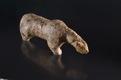
Photo: H. Jensen. Copyright University of Tübingen
The discovery of this ivory head helps to complete a figurine which now can be recognized as a lion – and demonstrates that it is possible to reassemble often fragmentary figurines from the earlier excavation. The new discovery is presented in the 2013 edition of the journal “Archäologische Ausgrabungen in Baden-Württemberg”.
Side view of the lion figurine. Mammoth ivory, found at Vogelherd Cave in southwestern Germany. Approx. 40,000 years old.

Photo H. Jensen. Copyright University of Tübingen
Vogelherd Cave is located in the Lone Valley of southwestern Germany and is by far the richest of the four caves in the region that have produced examples of the earliest figurative art, dating as far back as 40,000 years ago. Overall, Vogelherd Cave has yielded more than two dozen figurines and fragments of figurines.
Re-excavation of the sediments from Vogelherd Cave

Photo: M. Zeidi. Copyright University of Tübingen
While the work of fitting together thousands of small fragments of mammoth ivory from Vogelherd is just beginning, the remarkable lion figurine, now with its head, forms an important part of the display of the earliest art at the Museum of the University of Tübingen (MUT) in Hohentübingen Castle.
Professor Nicholas Conard and his excavation assistant Mohsen Zeidi today presented the new discovery and discussed its scientific importance, after which the find rejoined the permanent exhibit at MUT. Prof. Ernst Seidl of MUT commented on the importance of the Vogelherd discoveries for the University and the region.
Prof. Gustav Riek in front of Vogelherd Cave during excavations in the summer of 1931.

Photo: Copyright University of Tübingen
Contacts and sources:
Prof. Nicholas Conard Ph.D.
University of Tübingen
Institute of Prehistory and Medieval Archaeology
Senckenberg Center for Human Evolution and Palaeoenvironment Tübingen
One Giant Leap For Unmanned-Kind, FAA Approves Two New Drones For Domestic Flyovers
July 28th, 2013By Alton Parrish.
The Federal Aviation Administration has issued restricted category type certificates to a pair of unmanned aircraft systems (UAS), a milestone that will lead to the first approved commercial UAS operations later this summer.
The newly certified UAS—Insitu’s Scan Eagle X200 and AeroVironment’s PUMA—are “small” UAS weighing less than 55 pounds. Each is about 4 ½ feet long, with wingspans of ten and nine feet, respectively.
When Insitu first supported the U.S. Marine Corps in 2004 combat operations, ScanEagle offered a choice of either industry-leading electro-optic (EO) or long-wave infrared (LWIR) imagers. Over the years, Insitu added to that. Today the field-configurable NightEagle™ variant of ScanEagle carries a mid-wave infrared imager (MWIR) for daylight-quality infrared imagery, and a dual-bay option lets customers carry both EO and LWIR imagers at once.

The major advantage of having type-certificated UAS models available is that they can be used commercially. The Scan Eagle and PUMA received Restricted Category type certificates that permit aerial surveillance. Until now, obtaining an experimental airworthiness certificate – which specifically excludes commercial operations—was the only way the private sector could operate UAS in the nation’s airspace.
AeroVironment’s PUMA

Previous military acceptance of the Scan Eagle and PUMA UAS designs allowed the FAA to issue the Restricted Category type certificates.
A major energy company plans to fly the ScanEagle off the Alaska coast in international waters starting in August. Plans for the initial ship-launched flights include surveys of ocean ice floes and migrating whales in Arctic oil exploration areas. The PUMA is expected to support emergency response crews for oil spill monitoring and wildlife surveillance over the Beaufort Sea.
Issuing the type certificates is an important step toward the FAA’s goal of integrating UAS into the nation’s airspace. These flights will also meet requirements in the FAA Modernization and Reform Act of 2012 that define Arctic operational areas and include a mandate to increase Arctic UAS commercial operations.
10 Historical Events That Wouldn’t Have Happened If The Internet Existed
July 27th, 2013
By Alton Parrish.
Despite the fact that it’s only been in existence for roughly the last two decades, it’s become difficult to imagine what the world was like pre-internet. An entire generation of teens and young adults have no recollection of a time without web access, and those who do have little to no desire to go back. The way we work, pay bills and entertain ourselves has become so dependent on the internet that it’s an inextricable part of our daily lives. On the opposite side of the coin, imagining a world where internet always existed can be mind-blowing; here are ten events that would never have happened in a connected historical world
Contacts and sources:
Melanie Slaugh